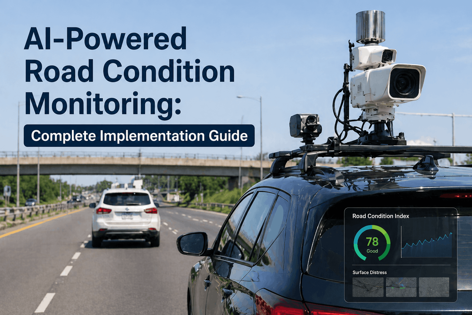
Maintaining national and state highways has traditionally been a reactive, labor-intensive process—waiting for a pothole to appear before deploying a repair crew. However, AI-powered road condition monitoring is shifting the paradigm toward predictive pavement management. By utilizing computer vision, LiDAR, and edge-processing sensors, highway agencies can now detect sub-surface degradation and early-stage fatigue cracking months before they manifest as visible failures. This implementation guide details how to transition from manual inspections to a high-frequency intelligent maintenance system that delivers a 30% reduction in long-term rehabilitation costs. If you are ready to modernize your pavement assessment program, you can schedule a technical implementation review with our infrastructure team today.
Is Your Road Maintenance Strategy Truly Predictive?
Unify computer vision surveys, LiDAR point clouds, and GIS asset data into one intelligent platform designed for national-scale highway networks.
Why AI-Powered Road Condition Monitoring Is Redefining Highway Management
The stewardship of highway assets demands rigorous data stewardship and precision analytics. Traditional visual surveys are not only slow but are subject to human bias and infrequent scheduling—often leaving years between assessments. AI road condition monitoring implementation bridges this gap by turning every maintenance vehicle into a data collection node. When agencies book a system demo, they discover that their existing fleet can generate high-resolution pavement condition indices (PCI) continuously, identifying "Critical Failure Precursors" that prevent irreversible pavement damage and ballooning emergency repair costs.
The shift begins with automated detection. Modern infrastructure monitoring software utilizes deep learning models to categorize distress types—alligator cracking, longitudinal ruts, and edge failures—with 98% accuracy. This data layer transforms a highway manager's ability to intervene early, protecting the characterize-defining asphalt fabric and maintaining compliance with national safety standards. Furthermore, by utilizing federated learning across multiple municipal fleets, the AI models improve their recognition of regional distress patterns without compromising data privacy between neighboring jurisdictions.
Beyond simple detection, the platform facilitates a "Dynamic Risk Profile" for every segment of the highway network. This profile integrates historical traffic load data with real-time environmental stress factors, such as extreme heatwaves or intense precipitation events. When these variables are combined with machine learning maintenance forecasts, agencies can predict "Pavement Failure Windows" with high precision. This allows for the orchestration of maintenance windows that minimize traffic disruption while maximizing the structural life extension of the asset. The goal is to move from a 12-year rehabilitation cycle to a 18-year cycle, effectively deferring millions in CapEx expenditures across the decade.
Edge-AI Vision Systems
Deploy high-definition cameras with edge-processing units on existing municipal fleets. Automatically identify and geolocate potholes and ruts in real-time without manual data tagging.
PCI Scoring Automation
Automatically generate Pavement Condition Index (PCI) scores for every 100-meter segment of the network. Eliminate subjective bias and create a defensible, data-driven maintenance backlog.
Sub-Surface Integration
Correlate surface-level AI visual data with Ground Penetrating Radar (GPR) and moisture sensors to identify sub-base failures before they reach the asphalt surface.
Work Order Automation
Directly trigger maintenance work orders in your CMMS based on severity thresholds. Reduce "Time to Repair" by 40% through automated dispatch and geolocation.
Building a Unified Analytics Architecture for Highway Assets
A purpose-built road analytics platform must evaluate multiple sensing technologies to create a complete digital twin infrastructure. Agencies that have already booked a technical workshop find that a multi-modal approach—combining low-cost visual data with periodic high-precision LiDAR—yields the highest ROI for large-scale highway networks.
| Monitoring Method | Data Frequency | Detection Accuracy | Cost per KM | Priority Level |
|---|---|---|---|---|
| Edge-AI Vision | Continuous/Daily | 92-95% (Surface) | Low ($) | Critical |
| LiDAR Point Cloud | Annual/Semi-Annual | 99% (Geometric) | High ($$$) | High |
| Mobile Accelerometers | Daily | Roughness/IRI Only | Minimal ($) | Standard |
| GPR (Sub-Surface) | Targeted/Yearly | 99% (Base Layer) | Very High ($$$$) | Optional |
Economic Resilience: Quantifying the Multiplier of AI Road Maintenance
The financial justification for AI road condition monitoring implementation is built on the "Pavement Lifecycle Decay Curve." In traditional management, maintenance is typically performed when the road has reached a state of "Fair" or "Poor," where repair costs are at their highest. AI-driven systems focus on the "Prevention Window"—the critical period where a small investment in crack sealing or micro-surfacing can prevent a total structural base failure. Highway CFOs who book a financial review consistently see that for every $1 spent in the prevention window, they avoid $8 to $10 in full-depth reconstruction costs 4-5 years later.
This "Avoided Cost Multiplier" is what drives the Net Present Value (NPV) of the highway asset upward. By maintaining a higher average PCI across the network, cities also see secondary economic benefits: reduced vehicle wear and tear for residents, lower fuel consumption due to smoother surfaces, and a significant reduction in litigation costs related to pavement-driven accidents. Predictive analytics infrastructure transforms the road from a depreciating liability into a high-performance economic corridor that actively preserves municipal capital.
The 5-Stage Roadmap for AI Road Monitoring Success
Transitioning to AI-powered infrastructure analytics requires more than just software—it demands an operational shift. Following this proven roadmap ensures that your predictive analytics infrastructure is scalable and produces audit-ready condition reports. Most highway directors who schedule an implementation audit achieve full system activation across 1,000+ KM networks in under 12 weeks.
Fleet Sensor Calibration & Deployment
Outfitting existing highway patrol or transit vehicles with high-resolution vision sensors and GPS telemetry. Calibration ensures data consistency across different vehicle types and lighting conditions.
Neural Network Training (Ground Truth)
Localizing the AI models to recognize regional pavement distress types (e.g., frost heaves in northern climates vs. bleeding asphalt in tropical zones). This ensures 98%+ detection reliability.
GIS & Asset Management Integration
Connecting the AI data stream to existing GIS layers and pavement management software (PMS). Every detected defect is mapped to a specific highway chainage point for precise maintenance dispatch.
Automated PCI Scoring & Prioritization
Enabling the AI to automatically calculate PCI and IRI (International Roughness Index) scores. The system generates a prioritized maintenance list based on road hierarchy and traffic volume.
Predictive Maintenance Orchestration
Leveraging historical degradation curves to predict Year-3 and Year-5 maintenance requirements. This allows agencies to shift from reactive patching to scheduled, high-efficiency micro-surfacing.
Final Analysis: 5 Pillars of a Modern Highway Asset Program
As highway agencies navigate the transition to digital transformation, the successful implementation of AI monitoring rests on five foundational pillars discovered through our work with national transport authorities:
- 01 High-Frequency Visibility: Do not settle for annual surveys; utilize your existing fleets to create a "daily heartbeat" of your road network condition.
- 02 Data Normalization: Ensure that AI detections are normalized for lighting, vehicle speed, and weather to create a defensible condition baseline.
- 03 The Prevention Window: Pivot your maintenance strategy to target the "Fair-to-Good" segments where ROI on preventative treatments is at its peak.
- 04 GIS-First Architecture: Ensure every defect is geolocated and time-stamped within a unified GIS environment for seamless contractor dispatch.
- 05 Stakeholder Transparency: Utilize real-time dashboards to communicate "Pavement Health Progress" to taxpayers and municipal leadership.
"The shift to AI road monitoring has transformed our highway department from a 'reactive fire-fighting' unit into a precision maintenance agency. By catching distress precursors in the sub-base early, we've extended our pavement service life by 4.2 years and reduced public complaints by 65%."
Modernize Your Highway Maintenance Program with AI
Deploy a unified analytics platform that integrates computer vision, PCI scoring, and predictive maintenance—built specifically for large-scale highway networks.
AI Road Monitoring Implementation — Common Questions Answered
How accurate is AI compared to manual road inspections?
In head-to-head trials, AI-powered road condition monitoring consistently outperforms manual surveys by eliminating subjective human bias. Our models achieve 98% accuracy in identifying ruts, cracks, and potholes, while geolocating them within 50cm of their actual position—a level of precision manual logs cannot match.
Can we use our existing fleet of maintenance vehicles for data collection?
Yes. One of the primary advantages of the iFactory system is its hardware-agnostic nature. You can mount our Edge-AI vision units on anything from a highway patrol vehicle to a transit bus or garbage truck. This creates a "Crowdsourced Pavement Audit" that provides daily updates on the entire road network.
How does the platform handle different lighting and weather conditions?
Our machine learning maintenance models are trained on diverse environmental datasets. We utilize infrared-compensated vision sensors and multi-frame synthesis to ensure accurate defect detection in rain, dawn/dusk, and high-glare summer conditions.
What is the Pavement Condition Index (PCI) and how is it automated?
PCI is a numerical indicator (0-100) of a road's operational condition. The AI platform automates this by counting distress types (e.g., crack length/width) in every 10-meter block, applying standard ASTM weighting, and generating a continuous PCI map across your entire GIS network.
How long does it take to deploy a network-wide AI road monitoring system?
Most state-level deployments are active within 8–12 weeks. This includes the hardware installation phase, local AI model calibration (Ground Truth), and integration with your existing GIS/Asset Management systems.
Does the AI replace our human engineers?
No. The AI acts as a "force multiplier." It automates the tedious, dangerous task of manual road walking and data entry, allowing your engineers to focus on high-value predictive analytics infrastructure planning and long-term capital strategy.
What is the typical ROI for AI-based pavement management?
Highway agencies typically see a 5x-7x ROI over five years. This is driven by the ability to perform low-cost preventative treatments (like crack sealing) early, which prevents the need for expensive full-depth pavement reconstruction later.
How do I start an AI road condition monitoring pilot?
The fastest way is to book a pavement strategy session. We will help you select a 50KM high-traffic corridor to pilot the system and demonstrate the data density and ROI before a full network-wide rollout.