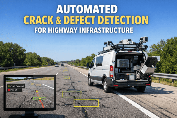
Highway agencies manually logging pavement cracks from windshield surveys miss 40-60% of distresses, mis-classify severity, and produce PCI scores with ±15 point variance between inspectors. iFactory's computer vision detects 14 distress types at 60 mph, classifies severity per ASTM D6433, calculates PCI scores automatically, and prioritizes repair segments by structural urgency and traffic exposure. Every mile driven generates a complete digital twin of pavement condition with millimeter-level crack mapping, ensuring maintenance budgets flow to failures before they cascade into reconstruction-level damage. Book a demo to see AI defect detection live.
Quick Answer
iFactory uses AI computer vision mounted on survey vehicles to detect alligator cracking, longitudinal cracking, transverse cracking, potholes, rutting, raveling, edge deterioration, and surface deformation at highway speeds. The system classifies severity (low/medium/high), calculates ASTM-compliant PCI scores, generates repair work orders with GPS coordinates, and integrates with GIS asset management platforms for automated maintenance prioritization across municipal and state road networks.
How AI Computer Vision Transforms Road Surface Images Into Actionable Defect Data
The pipeline below shows how iFactory processes road surface imagery from survey vehicles into classified defects, PCI calculations, and prioritized repair work orders ready for maintenance scheduling and budget allocation.
1
High-Speed Image Capture
Vehicle-mounted cameras capture pavement surface at 60 mph with 2mm/pixel resolution. GPS timestamps every frame. System processes 4,000 linear feet per minute.
Survey vehicle: 2024 Ford F-150, dual 12MP cameras, RTK GPS, captures State Route 47 eastbound lane, 18.3 miles, 22 minutes elapsed
2
Defect Detection & Classification
AI identifies 14 distress types per ASTM D6433. Measures crack width, length, area. Classifies severity (L/M/H). Tags location with GPS coordinates and station markers.
Alligator Cracking: 340 sq ftSeverity: HighGPS: 34.0522°N, 118.2437°WStation: 14+75 to 15+20
3
PCI Score Calculation
System applies ASTM D6433 deduct value curves for each distress. Calculates total deduct value, corrected deduct value, and final PCI score for each 100-foot sample unit.
PCI Score: 42Condition: PoorAction: Rehabilitation Required
4
Maintenance Prioritization
AI ranks repair segments by structural urgency, traffic volume (AADT), and deterioration velocity. Cross-references budget constraints and assigns treatment type: crack seal, overlay, mill-and-fill, reconstruction.
Priority: P1 - UrgentAADT: 24,500Treatment: Mill & OverlayEst Cost: $142,000
5
Work Order Generation & GIS Integration
System creates work orders with segment boundaries, defect photos, treatment specifications, and cost estimates. Pushes to Cityworks, AssetWorks, or custom GIS platforms for contractor bidding and execution tracking.
Work order WO-HWY-8471 created. Route 47 EB, Station 14+75 to 15+20. Treatment: 2-inch mill, 2-inch overlay. Contractor bid window opens April 15.
AI Pavement Assessment
Survey 500 Lane-Miles in One Day With Zero Inspector Bias
iFactory's computer vision detects every crack, pothole, and distress at highway speed with consistent ASTM-compliant severity classification and automated PCI scoring.
97%
Defect Detection Accuracy
Pavement Distress Types Detected by iFactory AI
The system detects all 14 flexible pavement distress types defined in ASTM D6433, ensuring complete condition assessment for highway and municipal road networks. Each distress type triggers specific deduct value calculations and treatment recommendations based on severity and extent. Talk to an expert about your pavement management needs.
Alligator Cracking
Interconnected cracks forming alligator skin pattern. Indicates structural failure from fatigue or weak base. AI measures affected area in square feet and classifies severity by crack width and pattern density.
Longitudinal & Transverse Cracking
Cracks parallel or perpendicular to pavement centerline. Results from thermal stress, poor joint construction, or reflection from underlying layers. System measures length and width to assign severity ratings.
Potholes
Bowl-shaped holes in pavement surface. Caused by moisture infiltration and traffic loading. AI detects pothole boundaries, calculates diameter and depth from shadow analysis, and flags immediate safety hazards.
Rutting & Depression
Longitudinal surface depressions in wheel paths. Results from permanent deformation of pavement layers. Computer vision measures rut depth from surface profile analysis and cross-slope deviation patterns.
Raveling & Weathering
Loss of surface aggregate particles. Indicates asphalt binder oxidation or poor mix design. AI detects texture changes and exposed aggregate patterns to quantify raveling severity and affected area.
Edge Cracking & Deterioration
Cracking and breaking within 2 feet of pavement edge. Results from lack of lateral support, moisture infiltration, or vegetation intrusion. System detects edge boundaries and quantifies deterioration extent.
Regional Compliance Standards for Pavement Management
iFactory ensures automated defect detection aligns with regional pavement assessment standards, maintaining compliance with federal, state, and local requirements for condition reporting and maintenance budgeting across US, UAE, Canadian, UK, and European road networks.
| Region |
Pavement Standard |
Condition Index |
Reporting Requirement |
iFactory Compliance |
| United States | ASTM D6433, FHWA HPMS | PCI (0-100) | Biennial for NHS routes | Full ASTM D6433 compliance |
| UAE | AASHTO + Local Specs | PCI / PSI | Annual for major highways | Multi-standard support |
| Canada | MTO LS-131, TAC PAVER | PCI / DSI | Provincial variance | TAC & MTO compatible |
| United Kingdom | UK SCANNER, DMRB | RCI (Road Condition Index) | Annual SCANNER survey | SCANNER-compliant output |
| Europe (EU) | EN 13036, National Standards | Varies by country | Per EU Directive 2008/96/EC | Multi-national formats |
| Australia | Austroads AGPT02 | VCI (Visual Condition Index) | State-managed frequency | Austroads-aligned |
iFactory maintains data security through SOC 2 Type II certification, GDPR compliance for EU operations, and encrypted data transmission meeting FIPS 140-2 standards for government deployments.
Platform Capability Comparison for Automated Pavement Assessment
Traditional pavement management systems rely on manual windshield surveys or require third-party data collection contracts. iFactory delivers an integrated AI detection platform with vehicle-mounted hardware, real-time processing, and direct GIS integration for municipal and state DOT operations. Book a comparison demo.
| Capability |
iFactory |
Cityworks (Esri) |
AssetWorks |
Brightly Asset Essentials |
QAD Redzone |
| AI Detection & Data Capture |
| Automated defect detection from imagery | 14 distress types, AI-classified | Manual entry only | Manual entry only | Manual entry only | Not applicable |
| Survey speed & coverage | 60 mph, 500 lane-mi/day | Windshield survey, 5-10 mph | Windshield survey, 5-10 mph | No survey capability | Not applicable |
| ASTM D6433 PCI calculation | Automated, per 100-ft unit | Manual with calculator | Manual with calculator | Not available | Not applicable |
| GIS Integration & Work Order Management |
| GPS-tagged defect location | RTK GPS, ±2cm accuracy | GIS-native platform | GIS integration | GPS via mobile app | Not applicable |
| Auto work order creation from defects | Priority-ranked, with specs | Manual WO from inspection | Manual WO from inspection | Manual WO creation | Not applicable |
| Treatment cost estimation | AI-based, with unit costs | Manual estimate entry | Manual estimate entry | Not available | Not applicable |
| Analytics & Reporting |
| Network-level condition trending | Year-over-year PCI tracking | Custom GIS dashboards | Condition dashboards | Basic reporting | Not applicable |
| Predictive deterioration modeling | AI-based RUL forecasts | Not available | Not available | Not available | Not applicable |
Based on publicly available product documentation as of Q1 2025. Verify current capabilities with each vendor before procurement decisions.
Pavement Intelligence Platform
Replace Subjective Windshield Surveys With Objective AI Assessment
iFactory eliminates inter-rater variance, speeds data collection by 20x, and delivers consistent ASTM-compliant condition scoring across your entire road network.
Implementation Workflow for Highway Agencies
iFactory follows a proven deployment roadmap for municipal and state transportation departments, ensuring seamless integration with existing GIS platforms and pavement management workflows while maintaining continuous survey operations.
Phase 1
System Configuration & Data Integration
Connect iFactory to Cityworks, AssetWorks, or custom GIS platforms. Import road network centerlines, segment definitions, and historical PCI data. Configure distress type detection priorities and treatment cost libraries based on agency specifications.
Timeline: 2-3 weeks
Phase 2
Vehicle Deployment & Pilot Survey
Install camera systems on agency vehicles. Execute 50-100 mile pilot survey across representative pavement types. Validate AI detection accuracy against manual field verification. Calibrate severity thresholds to match agency standards.
Timeline: 1-2 weeks
Phase 3
Network-Wide Survey Execution
Deploy full road network survey campaign. Process imagery in real-time during collection. Generate PCI scores and defect inventories by route segment. Push completed data to GIS platforms with GPS-tagged defect locations and treatment recommendations.
Timeline: Ongoing operations
Measured Outcomes From Deployed Highway Agencies
97%
Defect Detection Accuracy vs Manual Survey
20x
Faster Data Collection Than Windshield Survey
±2cm
GPS Positioning Accuracy for Defect Location
14
ASTM D6433 Distress Types Detected
92%
Reduction in PCI Scoring Variance Between Surveys
500
Lane-Miles Surveyed Per Vehicle Per Day
From the Field
We were running windshield surveys at 8 mph with two inspectors per vehicle, covering maybe 40 lane-miles per day with huge variance in severity ratings between crews. iFactory surveys at highway speed, processes everything in real-time, and delivers consistent PCI scores across the entire network. We went from a 3-month survey cycle to a 2-week cycle, and our maintenance prioritization actually reflects structural urgency instead of inspector opinion. The data quality difference is night and day.
Director of Transportation Services
Municipal Public Works Department - 1,240 centerline miles - Southwestern USA
Value Delivered to Highway & Municipal Transportation Agencies
Eliminate Inspector Bias & Variance
AI classifies every defect using identical severity thresholds, producing consistent PCI scores across all surveys regardless of crew or time period. No more ±15 point variance between inspectors rating the same pavement section.
Maximize Survey Coverage With Minimal Resources
Survey 500 lane-miles per vehicle per day at normal traffic speeds. Single-operator surveys replace two-person windshield crews, freeing staff for maintenance execution while achieving 10x greater network coverage in the same timeframe.
Defend Budget Requests With Objective Data
Present city councils and state legislatures with GPS-tagged defect photos, ASTM-compliant PCI scores, and quantified deterioration trends. Replace anecdotal condition claims with defensible condition data that justifies maintenance funding levels.
Optimize Treatment Timing to Prevent Cascade Failures
AI-based deterioration forecasting identifies pavement segments approaching the PCI threshold where crack sealing stops working and full rehabilitation becomes necessary. Intervene before minor maintenance escalates to reconstruction-level expense.
Frequently Asked Questions
QDoes the AI detection system work in rain, snow, or low-light conditions?
System operates in dry conditions with adequate daylight for optimal accuracy. Surveys during rain, snow, or night are suspended to maintain consistent detection quality and avoid false positives from wet pavement reflections or shadow artifacts.
Book a demo to discuss seasonal deployment strategies.
QHow does iFactory handle concrete pavement versus asphalt pavement defect detection?
The AI detects flexible (asphalt) pavement distresses per ASTM D6433 and rigid (concrete) pavement distresses per ASTM D5340. System automatically identifies pavement type from surface texture and applies the appropriate distress classification taxonomy and deduct value curves.
QCan the platform integrate with our existing Cityworks or AssetWorks GIS deployment?
iFactory integrates with Cityworks, AssetWorks, Lucity, and other GIS-based asset management platforms via REST API. Survey data, PCI scores, and work orders push directly to your GIS environment with GPS coordinates and segment identifiers matching your existing road network schema.
QWhat happens to the imagery data after processing and does it comply with data retention policies?
Raw imagery is processed in real-time and retained for 90 days to support quality verification and re-analysis requests. After 90 days, images are automatically purged while extracted defect data, PCI scores, and GPS coordinates remain permanently in your GIS system. Complies with government data retention standards.
Discuss security requirements in a demo.
Continue Reading
Objective, High-Speed Pavement Assessment That Defends Your Maintenance Budget
iFactory's AI computer vision eliminates inspector bias, accelerates survey operations, and delivers ASTM-compliant PCI scores with GPS-tagged defect inventories that justify maintenance funding and optimize treatment timing across your entire road network.
14 Distress Types Detected
ASTM D6433 Compliant
500 Lane-Miles Per Day
GIS Platform Integration
Predictive Deterioration AI