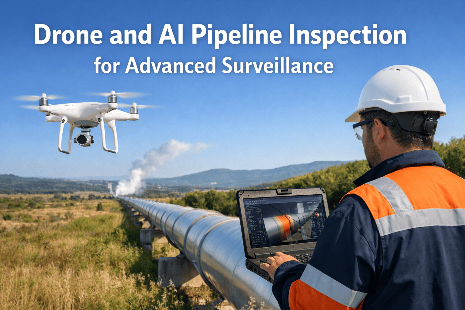
IFactory's autonomous drone fleet integrated with AI-powered analytics completes comprehensive pipeline corridor surveys at 15-30 miles per hour flight speeds capturing thermal imagery detecting temperature anomalies from leaks or coating defects, optical gas imaging identifying methane and hydrocarbon vapor releases invisible to visual inspection, high-resolution photography documenting right-of-way encroachments and surface conditions, and LiDAR terrain mapping measuring ground movement, erosion patterns, and pipeline exposure risks, processing inspection data through deep learning models trained on 100,000+ pipeline anomaly images achieving 96% defect detection accuracy while reducing inspection costs 75% and completing monthly surveillance cycles versus quarterly manned patrols enabling early intervention preventing failures before escalation to emergency response situations. Book a demo to see drone AI inspection for your pipeline network.
Upstream Gathering Systems
Wellhead gathering networks collect production from multiple wells transporting through low-pressure (150-600 psi) pipelines to central facilities across oil fields and gas basins. Gathering systems traverse remote locations including desert environments, mountainous terrain, agricultural lands, and undeveloped acreage where ground access requires negotiating multiple property owners, navigating unmarked roads, and traversing difficult terrain unsuitable for vehicle patrols. Traditional inspection challenges include infrequent surveillance (annual or longer cycles), limited route coverage (60-75% accessibility), and delayed threat detection allowing third-party damage, corrosion, and environmental conditions to progress undetected. Drone surveillance completes monthly inspection cycles capturing 95%+ route coverage including previously inaccessible segments, identifying wellhead leak signatures through thermal imaging, detecting unauthorized excavation and equipment installation threatening pipeline integrity, and documenting vegetation encroachment or erosion requiring right-of-way maintenance before conditions compromise pipeline safety.
Midstream Transmission Pipelines
Long-distance transmission systems transport products hundreds or thousands of miles at high pressures (800-1,440 psi) through diverse terrain including river crossings, mountain passes, agricultural zones, suburban areas, and environmentally sensitive regions. Transmission pipeline inspection faces regulatory requirements under PHMSA integrity management rules mandating periodic patrol frequency (minimum every 2 weeks for high-consequence areas, quarterly for rural segments), right-of-way condition documentation, and third-party activity monitoring. Manned helicopter patrols operating at $1,200-$2,500 per hour achieve limited inspection detail from 200-500 feet altitude missing early-stage anomalies, weather limitations ground operations 15-25% of scheduled flights, and pilot availability constraints delay inspection schedules impacting regulatory compliance. Autonomous drones fly 50-200 feet above ground level capturing 10x image resolution enabling identification of coating damage, small leaks, vegetation stress patterns indicating subsurface issues, erosion progression, and construction encroachment, operating in marginal weather conditions (25 mph winds, light precipitation) extending inspection availability, and completing 500-mile corridor surveys in 2-3 days versus 1-2 weeks for manned patrols reducing inspection cycle time and enabling rapid response to integrity threats.
Downstream Distribution Networks
Distribution pipelines deliver refined products from terminals to airports, bulk plants, and retail facilities operating at moderate pressures (100-400 psi) through urban and suburban areas with high population density and extensive third-party infrastructure crossings. Distribution system surveillance operates under strict regulatory oversight requiring weekly or biweekly patrols in populated areas, immediate response to construction activity notifications (one-call tickets), and documented right-of-way condition assessments. Ground patrols using vehicles achieve 70-85% route coverage missing segments blocked by traffic, private property access restrictions, and construction zones, while visual observation from moving vehicles detects only obvious threats missing subtle indicators of developing problems. Drone inspection provides 100% route coverage flying over traffic congestion and access obstacles, identifies construction equipment proximity to pipelines before excavation begins enabling proactive engagement with contractors, detects pavement cracking or settlement patterns indicating subsurface pipeline movement or soil instability, and documents encroachment progression through comparison with historical imagery establishing violation timelines supporting enforcement actions and damage prevention programs protecting high-consequence urban pipeline segments.
Pipeline failures from undetected integrity threats force emergency shutdowns costing $500,000-$4 million per incident including product loss (crude oil spills averaging 8,000-25,000 gallons, natural gas releases venting 50,000-200,000 MCF), environmental cleanup expenses (soil remediation, groundwater monitoring, habitat restoration), regulatory fines from EPA and state agencies ($250,000-$2 million per violation), and service interruption impacts affecting downstream customers, refineries, and revenue commitments. Catastrophic failures requiring pipeline replacement extend outages 4-12 weeks accumulating economic losses while investigation, permitting, construction, and hydrostatic testing complete before service restoration. Early detection through comprehensive drone surveillance identifying coating damage, corrosion indicators, erosion exposure, and third-party threats enables proactive repair during planned maintenance outages rather than emergency response to failures, reducing average repair timeline from 30-45 days (emergency mobilization, regulatory clearance, expedited construction) to 5-10 days (scheduled repair with pre-positioned materials, advance permitting, optimized construction planning).
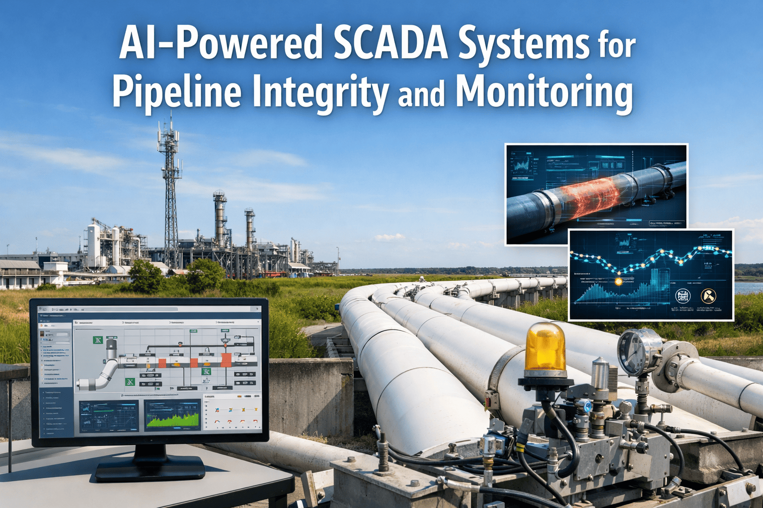
Pipeline SCADA systems monitor operational parameters (flows, pressures, temperatures) but operate independently from inspection programs, inline inspection data, and maintenance management systems preventing integrated integrity assessment. Inspection findings from helicopter patrols or ground surveys exist in separate databases (Excel spreadsheets, PDF reports, email archives) inaccessible to SCADA operators monitoring real-time conditions who lack context about known integrity threats, maintenance schedulers prioritizing repair activities without visibility to inspection severity classifications, and engineering teams performing risk assessments requiring manual compilation of disparate data sources. Connects to Your Existing DCS/SCADA & Historians: iFactory's drone inspection platform integrates bidirectionally with SCADA historians pulling operational data validating inspection findings through correlation with pressure anomalies, flow irregularities, or temperature deviations, pushing confirmed threats to control room displays alerting operators to potential integrity issues affecting monitored segments, and feeding geospatial inspection data into GIS-based integrity management systems enabling risk-based maintenance prioritization combining inspection findings, inline inspection results, cathodic protection data, and operational history into unified pipeline health assessments.
Traditional inspection programs operate reactively, identifying threats after occurrence rather than predicting degradation likelihood based on environmental trends, encroachment patterns, or vegetation health changes. Point-in-time inspections provide snapshots without historical context showing progression rates: is coating damage stable or expanding, has erosion accelerated or stabilized, are vegetation impacts worsening or improving. Without temporal analysis, operators lack quantitative evidence supporting intervention decisions, struggle to prioritize limited maintenance budgets across hundreds of potential repair locations, and miss opportunities to address slow-developing threats before emergency response required. AI-powered analytics process multi-year drone imagery databases identifying characteristic progression signatures predicting failure likelihood 60-180 days in advance: coating damage expansion rates correlate with time-to-corrosion based on moisture exposure and cathodic protection effectiveness, erosion velocity calculations forecast pipeline exposure dates enabling scheduled lowering or additional cover placement, vegetation encroachment trends predict equipment access obstruction requiring clearing before emergency repairs needed, and third-party activity patterns indicate construction development threatening future pipeline safety requiring engagement with developers and permitting authorities before conflicts arise.
AI Eyes That Detect Leaks Before They Escalate
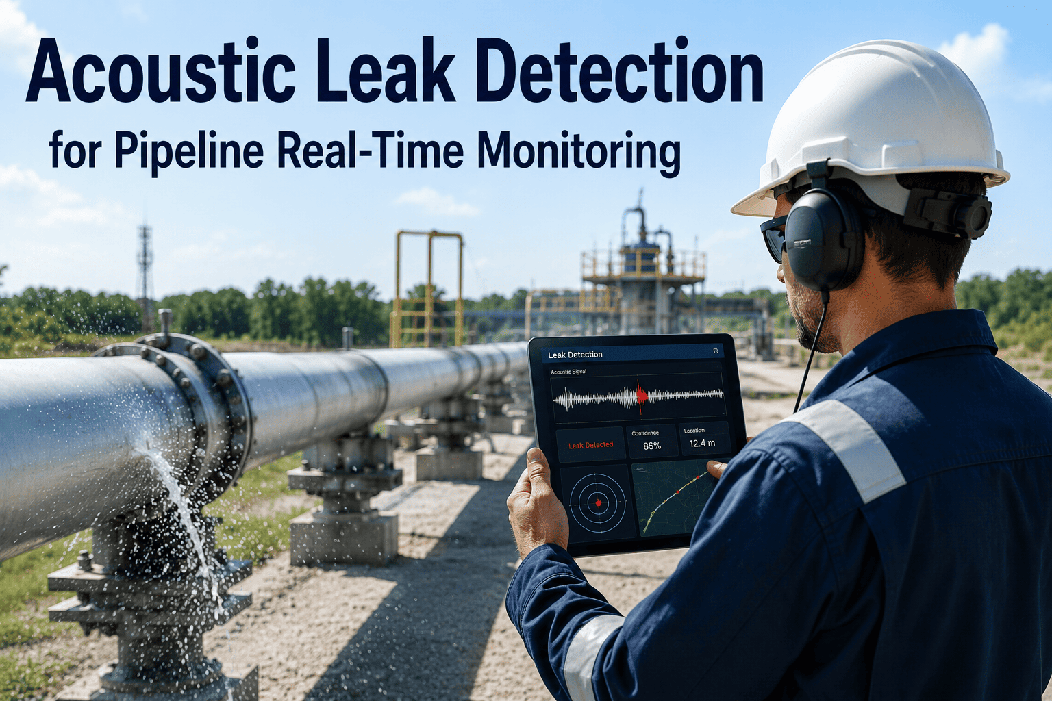
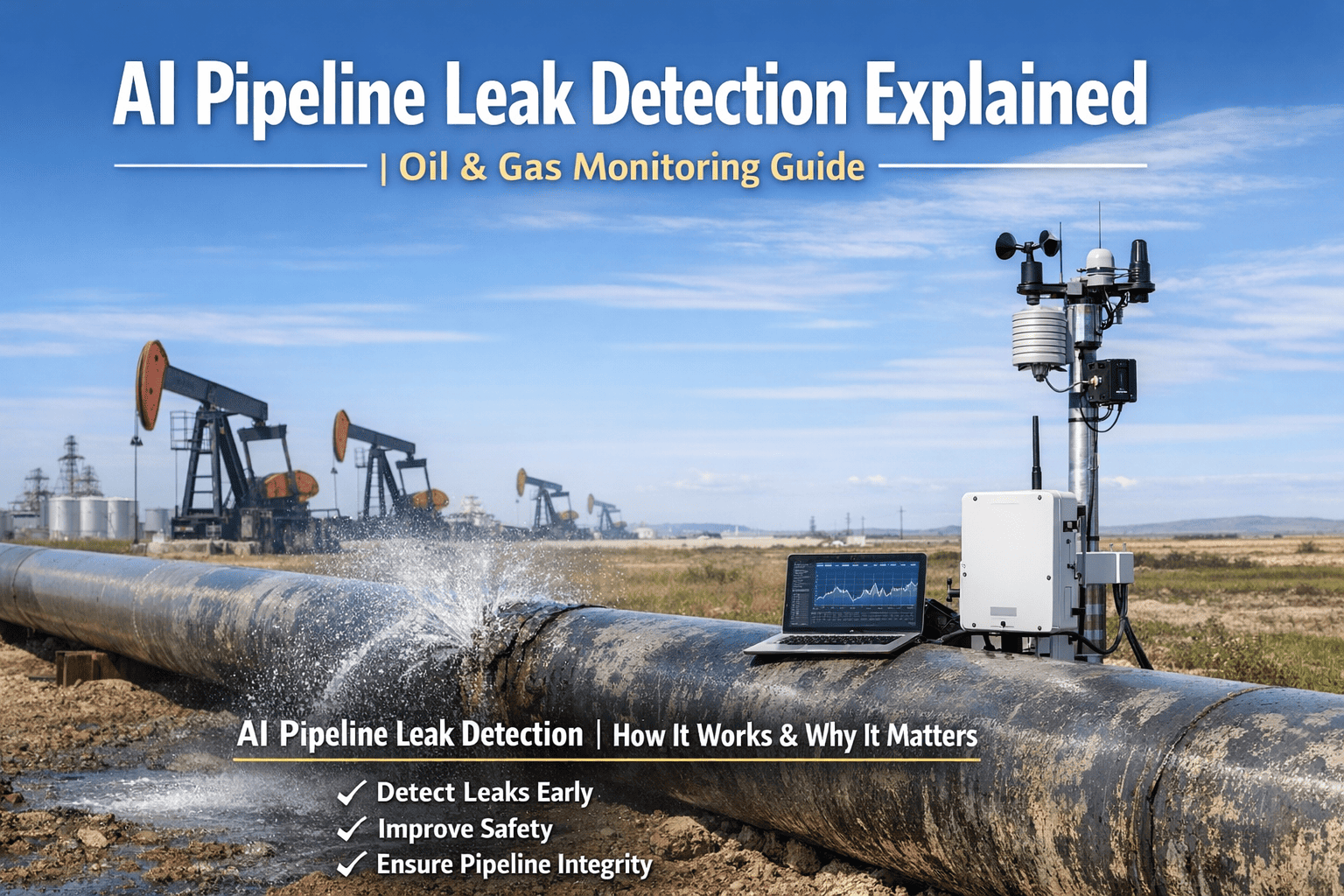
Thermal imaging cameras detect temperature anomalies from gas leaks (cold spots from Joule-Thomson expansion), liquid leaks (ground cooling from evaporation), coating defects (temperature differential patterns from disbondment), and equipment malfunctions (bearing failures, valve packing leaks, compressor issues) invisible to visual inspection. Optical gas imaging cameras visualize methane, VOC, and hydrocarbon vapor plumes in infrared spectrum enabling leak detection at 0.5-5 gallons per hour release rates below computational pipeline monitoring thresholds. Deep learning models trained on 100,000+ pipeline anomaly images classify thermal signatures, gas plumes, and surface conditions with 96% accuracy distinguishing genuine integrity threats from false indications (irrigation, natural gas vents, wildlife, shadows) that overwhelm human analysts reviewing thousands of inspection images.
Autonomous Flight Operations and Route Optimization
Pre-programmed flight paths follow pipeline centerline maintaining optimal altitude (50-200 feet AGL) and lateral offset capturing complete right-of-way coverage including both sides of corridor for encroachment detection and access route documentation. Automated takeoff/landing from portable ground stations enables remote deployment without operator travel to launch sites, reducing mobilization costs and enabling rapid response to integrity threats requiring immediate investigation. Obstacle avoidance using LiDAR and visual sensors navigates around trees, power lines, communication towers, and buildings maintaining safe clearances while adjusting flight path to maintain pipeline visibility. Weather monitoring integrates real-time forecasts canceling missions exceeding wind limits (25-30 mph depending on aircraft), precipitation thresholds, or visibility requirements while automatically rescheduling postponed segments maintaining overall inspection frequency compliance despite weather interruptions. Fleet management optimizes aircraft allocation across multiple pipeline systems balancing inspection priorities, weather windows, maintenance cycles, and operator availability maximizing asset utilization while meeting regulatory patrol requirements.
Predictive Maintenance with Integrity Forecasting
Time-series analysis compares multi-year inspection imagery identifying progression rates for coating damage, erosion, vegetation encroachment, and third-party development, forecasting intervention requirements 60-180 days in advance enabling scheduled repairs versus emergency response. Machine learning models correlate environmental factors (rainfall patterns, temperature cycles, construction activity) with degradation acceleration enabling risk-based inspection frequency optimization: high-risk segments increase to monthly surveillance, stable areas extend to quarterly cycles allocating limited drone resources to locations requiring enhanced monitoring. Predictive alerts integrate with maintenance management systems generating work orders when forecasted conditions approach critical thresholds (erosion reaching pipeline depth, coating damage expanding to cathodic protection shadow zones, vegetation obstructing emergency access), including recommended actions, cost estimates, and criticality rankings supporting budget justification and resource allocation decisions.
Work Order Automation
Anomaly detection alerts automatically generate CMMS work orders (IBM Maximo, SAP PM, Infor EAM integration) including threat classification (leak, corrosion, third-party, erosion, vegetation), GPS coordinates accurate to ±3 feet for field crew navigation, thermal images and analysis supporting field investigation, and severity rankings prioritizing response timing (immediate emergency response, 30-day scheduled repair, routine maintenance cycle). Integration with GIS mapping systems displays work order locations on pipeline schematics enabling supervisors to optimize crew routing, identify equipment/material requirements based on access conditions and threat types, and track repair completion through post-repair drone verification flights validating corrective actions eliminated identified threats. Automated notifications trigger stakeholder alerts: control room operators receive leak detections for flow/pressure monitoring correlation, environmental compliance teams receive notifications for regulatory reporting assessment, management receives critical threat summaries for situational awareness and resource allocation decisions.
Asset Lifecycle Management
Complete pipeline segment history tracking from construction through operation to replacement including drone inspection records, inline inspection results, cathodic protection surveys, failure events, and repair actions enabling data-driven integrity management decisions. Analytics identify chronic problem segments requiring replacement versus repair campaigns, optimize inspection frequencies based on threat probability models rather than fixed regulatory minimums, and support capital planning demonstrating investment justification through historical failure analysis and predicted risk reduction. Integration with inline inspection data correlates external observations with internal conditions: external coating damage locations prioritize internal inspection tool runs, internal metal loss features trigger targeted drone surveillance for external corrosion indicators, and combined data sets support engineering assessments determining remaining life and repair/replacement timing balancing safety, reliability, and cost optimization objectives.
Pipeline Integrity Monitoring
Multi-sensor payload integration combines thermal imaging for leak detection and coating assessment, optical gas imaging for methane/VOC visualization, high-resolution RGB photography for third-party activity and surface condition documentation, and LiDAR terrain mapping for erosion quantification and pipeline depth-of-cover verification in single flight mission. Geospatial data management links inspection findings to pipeline stationing systems (milepost references) enabling precise location communication to field crews, correlation with inline inspection features and cathodic protection test stations, and integration with one-call ticket systems identifying construction activity proximity requiring enhanced surveillance. Change detection algorithms compare current and historical imagery automatically flagging new anomalies (recent coating damage, erosion progression, third-party encroachment, vegetation changes) versus stable conditions requiring no action, reducing analyst review time 80% by filtering unchanged pipeline segments from detailed examination workflows.
OT Data Stays Inside Your Security Perimeter
Edge computing processes inspection imagery locally at pipeline facilities or regional offices without transmitting raw imagery to external cloud services, maintaining operational security and preventing exposure of pipeline routing, facility locations, or vulnerability information. Encrypted data transmission uses TLS 1.3 with certificate-based authentication for communications between drones, ground control stations, and central databases, role-based access controls limit inspection data visibility to authorized personnel, and comprehensive audit logs track all system access supporting cybersecurity compliance requirements. Deployment options include fully on-premises processing at operator control centers, hybrid architectures with local anomaly detection and cloud-based analytics for non-sensitive optimization algorithms, or air-gapped configurations for critical infrastructure requiring complete network isolation from internet connectivity meeting TSA pipeline security directives, NERC CIP requirements for electric utility pipelines, and CFATS chemical facility security standards.
Performance metrics based on typical pipeline corridor inspection implementations comparing autonomous drone operations versus traditional inspection programs.
Week 1-3
Route Planning and Regulatory Approvals
Engineering team reviews pipeline routing developing optimal flight paths maintaining visual access while respecting airspace restrictions (airports, military zones, populated areas). FAA Part 107 waiver applications submit for beyond visual line of sight operations including safety case documentation, operational procedures, and emergency protocols. Ground station locations identify along pipeline route enabling mission coverage from existing access points (pump stations, valve sites, meter stations) without requiring new infrastructure construction. Stakeholder coordination engages landowners, local authorities, and regulatory agencies communicating inspection program objectives, flight schedules, and contact procedures establishing operational acceptance supporting long-term surveillance activities.
Week 4-6
Equipment Deployment and Pilot Training
Drone fleet delivery includes aircraft, sensor payloads (thermal cameras, optical gas imaging, RGB photography, LiDAR), ground control stations, and communication equipment configured for pipeline surveillance missions. Pilot training completes FAA Part 107 certification for commercial operations plus manufacturer-specific aircraft operation, mission planning software, emergency procedures, and maintenance protocols. Initial flight operations conduct test missions along representative pipeline segments validating flight path programming, sensor performance, data quality, and anomaly detection capabilities before full-scale deployment authorization. Quality assurance reviews confirm detection accuracy targets achieved (95%+ on validation dataset) and false positive rates acceptable (under 10%) before operational transition.
Week 7-10
AI Model Training and Integration
Machine learning models train on operator-specific pipeline imagery incorporating historical inspection records, inline inspection results, and known anomaly locations learning characteristic signatures for leaks, corrosion indicators, third-party threats, vegetation issues, and terrain conditions unique to pipeline operating environment. Integration with SCADA historians enables operational data correlation validating leak detections through pressure/flow monitoring, inline inspection databases support automated feature correlation, and CMMS systems receive automated work order generation from inspection findings. Compliance reporting templates configure for PHMSA annual reports, EPA LDAR documentation, and state regulatory submissions automating documentation workflows reducing manual report preparation from weeks to hours.
Frequently Asked Questions
QHow does the platform integrate with existing PHMSA compliance and integrity management programs?
Automated documentation generates PHMSA patrol records with inspection dates, observations, and anomaly classifications formatted for annual report submissions. Integration with integrity management systems correlates drone findings with inline inspection results, cathodic protection surveys, and risk assessment models supporting API 1160/1173 programs. Threat classification follows PHMSA immediate, 180-day, and scheduled repair categories with automated work order generation and tracking ensuring regulatory response timeline compliance. Audit trail documentation provides timestamped flight logs, geotagged imagery, and analyst attribution demonstrating systematic inspection program execution meeting federal oversight requirements.
Book a demo for compliance documentation review.
QWhat is the typical cost comparison between drone inspection and traditional manned helicopter patrols?
Autonomous drone operations cost $15-$30 per pipeline mile versus $80-$150 for helicopter patrols, delivering 75% cost reduction while increasing inspection frequency and coverage. For 10,000-mile transmission system, annual savings reach $8-$10 million transitioning from quarterly helicopter surveys to monthly drone surveillance. Cost advantages derive from lower aircraft operating expenses (no pilot/observer labor, reduced fuel, minimal maintenance), enhanced efficiency (15-30 mph inspection speeds versus mobilization delays), and scalability (multiple aircraft operating simultaneously from distributed ground stations). Investment payback typically occurs within 18-24 months including aircraft acquisition, training, and program startup costs.
QDoes the platform support methane emissions quantification and ESG reporting requirements?
Yes. Optical gas imaging detects methane, VOC, and hydrocarbon releases with EPA Method 21 equivalent sensitivity, automated quantification algorithms calculate emission rates from plume characteristics using dispersion modeling, repair tracking verifies corrective actions completed within regulatory timeframes, and ESG reporting generates CDP questionnaires, TCFD disclosures, and GRI sustainability metrics. Continuous surveillance replaces quarterly manual LDAR surveys providing real-time emissions visibility supporting voluntary reduction commitments and demonstrating environmental stewardship through statistical analysis of leak detection frequency, repair completion rates, and year-over-year emissions reductions achieved versus baseline periods.
Talk to an Expert about ESG capabilities.
Deploy AI-Powered Autonomous Inspection Across Your Pipeline Network
96% Detection Accuracy
95%+ Route Coverage
75% Cost Reduction
Monthly Surveillance
PHMSA Compliant