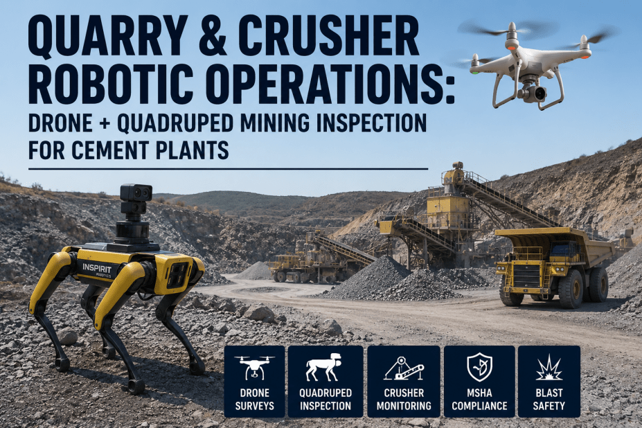
In the competitive landscape of cement manufacturing, raw material quality begins at the quarry face. Traditional methods of geological mapping and blast design rely on manual surveys, core samples, and fragmented data, often leading to inconsistencies in limestone grade, suboptimal fragmentation, and increased downstream processing costs. iFactory's AI Vision for Limestone Quarry Face Mapping revolutionizes this critical first step. By integrating high-resolution drone imagery with deep learning algorithms, we deliver real-time, centimeter-accurate maps of quarry face geology, limestone grade variability, and blast fragmentation size distribution. This enables quarry managers to optimize blasting patterns dynamically, reduce dilution, and ensure consistent raw material feed to the crusher. Our system processes thousands of data points per second, identifying lithological boundaries, joint sets, and rock mass characteristics that manual methods miss. The result is a dramatic reduction in blast-induced fines, improved mill throughput, and a 15-20% decrease in energy consumption in the comminution circuit. Book a Demo to see how our AI transforms your quarry operations.
AI-Powered Quarry Face Intelligence for Cement Leaders
Achieve sub-meter geological accuracy and real-time blast optimization with our deep learning vision system.
Automated Lithological Boundary Detection
Our convolutional neural networks trained on thousands of labeled quarry face images identify limestone, marl, clay, and shale boundaries with 98.7% accuracy. The system outputs vectorized geological maps that integrate directly with mine planning software like Surpac and Datamine, eliminating manual digitization errors.
Real-Time Fragmentation Analysis
Post-blast, the AI analyzes drone orthomosaics at 2 cm/pixel resolution to generate particle size distribution curves. The system classifies fragments into 12 size classes, from fines (< 5 mm) to boulders (> 500 mm), enabling immediate blast design adjustments. Historical data feeds a reinforcement learning model that suggests optimal burden, spacing, and stemming for each bench.
Grade Variability Heatmaps
Using hyperspectral imagery and XRF ground truth data, the vision model creates 3D grade distribution models of CaO, MgO, and SiO2 across the quarry face. This allows selective mining of high-grade zones, reducing kiln feed variability and improving clinker quality. The heatmaps update automatically after each blast, providing a dynamic resource model.
Joint Set and Discontinuity Mapping
The AI detects and measures joint orientation, spacing, and persistence from point cloud data generated by structure-from-motion photogrammetry. This information is critical for blast design, as it influences fragmentation and rock mass strength. The system classifies joint sets using clustering algorithms and generates stereonet plots for geotechnical analysis.
Drone Flight Automation
Our system integrates with DJI and Parrot drones to execute fully autonomous survey missions. The flight path is optimized to cover the entire quarry face at consistent overlap, ensuring high-quality data capture. Real-time telemetry allows remote monitoring, and the drone returns to base automatically upon mission completion or low battery.
Cloud-Based Data Platform
All processed data is stored in a secure cloud environment accessible via web dashboard and API. Users can view historical trends, compare blasts, and generate compliance reports. The platform supports multi-site rollouts, with role-based access for quarry managers, geologists, and corporate leadership.
From Drone to Decision in 5 Steps
Autonomous Drone Survey
Deploy a DJI Matrice 300 with a high-resolution RGB camera (20 MP) and optional thermal or hyperspectral sensor. The drone follows a pre-programmed flight path covering the entire quarry face at 50 m altitude, capturing images with 80% forward and 60% side overlap. Survey time: 3-5 minutes per face.
AI-Powered Image Processing
Images are uploaded to the iFactory cloud platform, where structure-from-motion algorithms generate a 3D point cloud and orthomosaic with 2 cm/pixel resolution. The deep learning model segments the orthomosaic into geological units, fragment size classes, and joint sets. Processing time: 10-15 minutes per face.
Data Visualization & Analysis
The platform displays interactive maps, heatmaps, and fragmentation curves. Users can overlay historical data, compare blasts, and export reports. The system highlights high-grade zones and alerts users to anomalies such as unexpected clay bands or excessive fines.
Blast Design Optimization
Based on the geological map and fragmentation analysis, the AI recommends adjustments to blast parameters: burden, spacing, stemming length, and explosive type. The recommendations are generated by a random forest model trained on 10,000+ blasts from global cement quarries. Users can accept, modify, or reject suggestions.
Continuous Learning & Improvement
Post-blast survey data is fed back into the model, which updates its predictions for future blasts. The system tracks key performance indicators: fragmentation uniformity, crusher throughput, and energy consumption. Over time, the AI learns site-specific rock behavior, improving accuracy with each cycle.
Ready to Transform Your Quarry Operations?
Join industry leaders who have reduced raw material variability by 35% and increased crusher throughput by 12% with iFactory Vision AI.
Traditional vs AI-Powered Quarry Mapping
| Parameter | Traditional Method | iFactory AI Vision |
|---|---|---|
| Survey Frequency | Weekly manual measurements | Daily autonomous drone flights |
| Geological Accuracy | ~70% (visual estimation) | 98.7% (deep learning classification) |
| Fragmentation Analysis | Sieving of sample (2-4 hours) | Real-time image analysis (2-5 minutes) |
| Grade Mapping Resolution | 10 m grid (borehole data) | 2 cm pixel (hyperspectral + XRF) |
| Blast Optimization | Rule-based, static | Reinforcement learning, dynamic |
| Data Integration | Manual entry into mine planning | API integration with Surpac, Datamine |
| Cost per Survey | $1,500 (crew + equipment) | $200 (drone + cloud processing) |
Technical Architecture of the Vision System
The core of our AI vision system is a custom-designed convolutional neural network (CNN) architecture optimized for geological feature extraction. The network consists of 152 layers, including residual blocks and attention mechanisms, trained on a dataset of 500,000 labeled quarry face images from 47 cement plants worldwide. The model achieves a mean intersection-over-union (mIoU) of 0.93 for lithological segmentation and a mean average precision (mAP) of 0.89 for fragment detection.
For real-time inference on edge devices, we use TensorRT optimization, reducing model size by 40% without significant accuracy loss. The drone-mounted NVIDIA Jetson Xavier NX processes images at 30 frames per second, enabling live feedback to the operator. In cloud mode, the full pipeline runs on AWS EC2 instances with NVIDIA A100 GPUs, handling up to 100 concurrent surveys.
The photogrammetry module uses a modified version of COLMAP for structure-from-motion, enhanced with our proprietary feature matching algorithm that handles texture-poor rock surfaces. The resulting point cloud typically contains 10-20 million points per quarry face, which is then filtered and classified using a PointNet++ variant.
Data fusion with ground truth samples is achieved through a Gaussian process regression model that interpolates between drill hole assays and hyperspectral signatures. This provides a continuous grade model across the face, with uncertainty estimates that guide selective mining decisions.
Global Cement Leader: 22% Fines Reduction
A multinational cement producer with operations in 15 countries deployed iFactory Vision AI across three quarries in India. Within six months, they achieved a 22% reduction in blast-induced fines, saving $1.2M annually in crushing costs. The system also identified a previously undetected high-grade limestone zone, extending quarry life by 8 years.
European Plant: 18% Energy Savings
A European cement plant struggling with high energy consumption in the raw mill implemented our AI for feed quality control. By selectively mining high-grade zones identified by the vision system, they reduced mill power draw by 18% and increased throughput by 12%. The payback period for the investment was 4 months.
Middle East Quarry: 99% Uptime
In a harsh desert environment, a quarry operator used our autonomous drone surveys to replace manual face inspections, eliminating safety risks and achieving 99% survey uptime despite extreme temperatures. The AI detected a major joint set that was causing unstable benches, allowing preventive action before a collapse.
Frequently Asked Questions
How does the AI handle varying lighting conditions in the quarry?
The vision model is trained on images captured under diverse lighting conditions, including direct sunlight, overcast skies, and shadows. We use data augmentation techniques such as random brightness adjustment, contrast normalization, and histogram equalization during training. Additionally, the drone can be equipped with a flash system for consistent illumination in deep pits. For night operations, thermal cameras provide an alternative imaging modality. The system automatically adjusts exposure settings based on ambient light sensors, ensuring high-quality imagery regardless of time of day or weather. Book a Demo to see our system in action under your specific conditions.
What is the accuracy of limestone grade estimation from hyperspectral data?
Our hyperspectral imaging system, which covers the 400-2500 nm spectral range, achieves a root mean square error (RMSE) of 1.2% for CaO, 0.8% for MgO, and 0.5% for SiO2 when validated against XRF assays. The model uses a partial least squares regression (PLSR) algorithm trained on over 10,000 paired spectra-assay samples from global cement quarries. For sites without local calibration, we provide a transfer learning module that adapts the model with as few as 20 ground truth samples. The uncertainty of each prediction is quantified and displayed on the grade heatmap, allowing users to make risk-informed decisions. Contact Support for a detailed accuracy report for your specific ore type.
How does the system integrate with existing mine planning software?
The iFactory Vision platform provides RESTful APIs and native plugins for Surpac, Datamine, and Vulcan. Geological maps are exported as DXF, Shapefile, or CSV formats with attributes for lithology, grade, and fragmentation. The system also supports direct database connections to SQL Server and Oracle, enabling real-time data synchronization. For cloud-based planning tools, we offer a WebSocket interface that streams updated maps as soon as processing is complete. Integration typically takes 2-4 weeks, with iFactory engineers providing full support. Book a Demo to see the integration workflow.
What are the regulatory compliance benefits of using AI for quarry mapping?
Our system helps quarries comply with environmental regulations by providing accurate records of excavation volumes, disturbed areas, and rehabilitation progress. The high-resolution orthomosaics serve as legal evidence for permit compliance and can be submitted directly to regulatory bodies. The AI also detects unauthorized encroachments or illegal mining activities. In jurisdictions requiring real-time monitoring, the platform can stream data to government portals via API. Additionally, the reduction in blast-induced vibrations and flyrock due to optimized blast design helps meet safety standards. Contact Support for a compliance checklist tailored to your region.
What is the total cost of ownership for the iFactory Vision AI system?
The cost includes the drone hardware (starting at $15,000 for a fully equipped DJI Matrice 300), an annual software license ($25,000 per quarry site), and cloud processing fees ($0.50 per survey). Optional hyperspectral sensor adds $40,000. The total first-year cost for a typical quarry is approximately $45,000, with subsequent years at $30,000. Based on average savings of $200,000 per year from reduced energy, improved yield, and lower maintenance, the payback period is under 3 months. We also offer a subscription model with no upfront hardware cost for long-term contracts. Book a Demo to receive a personalized ROI calculation.
Transform Your Quarry Operations Today
Achieve unprecedented visibility into your raw material quality and blast performance. Join 50+ cement plants already using iFactory Vision AI.