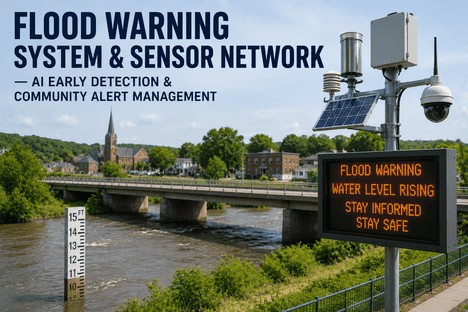
Flood Warning System & Sensor Network — AI Early Detection & Community Alert Management
By Grace on June 26, 2026
A retention pond rises six inches in an hour after a sudden downpour. A stream gauge two miles upstream crosses the action threshold. A stormwater pump station reports abnormal flow. These three events happen within twelve minutes of each other across a single municipal watershed — and in most organisations today, they are detected by three separate systems that do not share data, do not trigger coordinated alerts, and do not appear on the same screen for the EHS manager responsible for community flood safety. The global flood early warning systems market reached USD 1.82 billion in 2024 and is projected to grow at 7.9% annually to USD 3.62 billion by 2033. The smart flood alarm market alone is valued at USD 3.8 billion in 2025 and heading toward USD 7.66 billion by 2034. But the growth in sensor deployment is outpacing the integration infrastructure needed to make those sensors work as a coordinated warning network. When a retention system alarm fires in isolation, when a stream gauge alert reaches the operations team fifteen minutes after the event, and when the community notification workflow requires manual confirmation across three different dashboards before a warning is issued — the organisation does not have a flood warning system. It has a collection of detection points that happen to report data. iFactory's Flood Warning System with AI-powered sensor network integration and community alert management was built to close this gap.
AI Early Detection · Sensor Network Integration · Community Alert Management · Real-Time Flood Monitoring
Stream Gauges. Rain Sensors. Retention Systems. Pump Stations. One Unified Flood Warning Platform That Detects, Analyses, and Alerts Before Water Rises.
iFactory's flood warning module gives EHS managers and emergency operations teams a single real-time view of every sensor in the network — with AI-driven early detection, cross-sensor correlation, automated threshold escalation, and community notification workflows that reduce response time from minutes to seconds.
Projected flood early warning systems market by 2033 at 7.9% CAGR — organisations with integrated AI sensor networks will lead adoption and achieve faster ROI
43%
Of all natural disasters worldwide are floods — the most prevalent hazard type, impacting more than 2 billion people globally over the past three decades
30%
Average reduction in emergency response costs reported by early adopters of integrated AI-driven flood warning platforms with automated alert workflows
7.9%
Compound annual growth rate of the flood early warning systems market — driven by AI adoption, IoT sensor proliferation, and climate-driven event frequency
The Real Problem With Flood Warning Systems Is Not Sensor Coverage. It Is Sensor Disconnection.
The technical challenges of deploying flood sensors across a watershed are well understood. What is less discussed is the specific operational failure mode that emerges when those sensors — stream gauges, rain gauges, retention level monitors, pump station telemetry — operate in disconnected data environments. Each sensor type generates valuable data in isolation. But flood events do not respect sensor-type boundaries. A flash flood develops when rainfall intensity, stream capacity, retention system saturation, and ground absorption converge in a specific sequence. Detecting that sequence requires a system that correlates data across sensor types in real time.
How Disconnected Sensor Networks Fail During Flood Events
The Data Silo Problem
Stream gauge data lives in one system. Rain data lives in another. The correlation never happens.
When a municipality operates its stream gauges on one telemetry platform, its rain gauges on a second, and its retention pond monitors on a third, no single operator sees the converging conditions that precede a flood event. The EHS manager who could have issued a warning twenty minutes earlier is instead switching between tabs, comparing timestamps manually, and making a judgment call based on partial information. The window for early action closes while the operator is still reconciling data formats.
Delayed Detection + Missed Warning Window
The Threshold Gap
Each sensor fires its own alert at its own threshold. No system evaluates combined risk across the sensor network.
Individual sensors are configured with single-variable thresholds — a stream gauge alerts when water level exceeds four feet, a rain gauge alerts at two inches per hour. But the real flood risk emerges below these individual thresholds when multiple conditions occur simultaneously. A stream gauge at three feet with rainfall at 1.8 inches per hour and a retention pond at 85% capacity represents a higher risk profile than a stream gauge at four feet with no rainfall and empty retention — yet disconnected systems only see the first scenario as non-alerting and the second as alerting, producing a false sense of safety when the network needs it most.
False Negatives + Undetected Escalation
The Alert Fragmentation Issue
Different sensor alerts reach different people through different channels. No unified notification to the community.
When a pump station alert fires, it goes to the wastewater team. When a stream gauge alert fires, it goes to the stormwater team. When a rain intensity alert fires, it goes to the emergency management office. Each team receives a fragment of the risk picture, and none has the complete view needed to authorise a community-wide evacuation notice. The delay between first detection and community notification expands as the number of disconnected sensor systems grows — and in a flash flood scenario, minutes determine whether a warning reaches vulnerable populations before water does.
Fragmented Response + Community Risk
The Post-Event Data Loss
After the event, reconstructing what happened requires manual data pulls from every disconnected system.
Post-flood reporting and regulatory compliance depend on the ability to reconstruct event timelines with precision. When sensor data is distributed across multiple unintegrated platforms, the post-event analysis becomes a days-long exercise in data reconciliation — assuming every system maintained its timestamp accuracy and data retention. The result is that after-action reports are simplified, root causes are harder to identify, and the same sensor configuration gaps that contributed to delayed detection remain uncorrected for the next event.
Missing Root Cause + Repeat Failures
AI Early Detection · Unified Sensor Network · Cross-Sensor Correlation · Automated Community Alerting
Disconnected Sensors Do Not Make a Warning System. A Unified Platform That Correlates Every Data Point in Real Time Does. iFactory Is That Platform.
A single interface that ingests data from every sensor type in your network — stream gauges, rain gauges, retention monitors, pump telemetry — applies AI-driven correlation to detect developing flood conditions before any single threshold is breached, and triggers automated community alerts through SMS, email, siren, and digital signage from one unified workflow.
What iFactory's Flood Warning System Actually Does
iFactory is not a sensor dashboard layered on top of existing telemetry. It is a unified flood warning operations platform where every sensor type, every threshold configuration, every alert recipient, and every post-event report lives in a single data environment — with AI-powered cross-sensor correlation that detects developing flood conditions before any single variable reaches its critical threshold, and automated community notification workflows that turn detection into action without manual intervention.
Capability 01
Unified Sensor Network Integration — Every Data Point in One Real-Time View
Multi-Source Aggregation
iFactory ingests data from stream gauges, rain gauges, retention pond level monitors, pump station telemetry, weather station feeds, and satellite precipitation data into a single real-time dashboard. Each sensor type maintains its native data format and transmission protocol — iFactory handles the integration layer so the operator sees a unified watershed view without leaving the platform. The sensor health dashboard shows battery levels, signal strength, and last transmission time for every deployed unit, so maintenance teams know which sensors need attention before the next storm event. When a sensor goes offline, the platform alerts the field operations team automatically — eliminating the scenario where a critical gauge is discovered non-functional during an active flood event.
Multi-protocol sensor ingestion
Unified watershed dashboard
Sensor health & telemetry status
Capability 02
AI-Powered Early Detection — Cross-Sensor Correlation That Detects Flood Risk Before Any Single Threshold Is Breached
Predictive Risk Intelligence
The AI engine in iFactory's flood warning module continuously analyses incoming data from every connected sensor type, building a real-time risk profile that accounts for rainfall intensity, stream rise rate, retention system saturation, ground absorption capacity, and forecast precipitation. When the correlation model detects a developing flood condition — stream gauge rising at 1.2 feet per hour combined with rainfall at 1.6 inches per hour and retention at 78% capacity — the system escalates to an early warning state before any individual sensor reaches its critical threshold. This predictive capability extends warning lead time by detecting the convergence pattern that precedes flash flooding, rather than waiting for a single variable to cross a danger line. The AI model trains on historical event data from your specific watershed, learning the unique flood signatures that distinguish a non-threatening storm from a developing hazard in your geography.
Multi-variable risk correlation
Extended warning lead time
Watershed-specific AI training
Capability 03
Multi-Channel Community Alert Management — One Workflow Notifies Every Audience Through Every Channel
Unified Notification Engine
When the AI detection engine or a manual operator triggers a flood warning, iFactory's notification engine distributes the alert across every configured channel simultaneously — SMS to registered residents in the flood zone, email to municipal emergency response teams, siren activation at pre-installed community warning points, digital signage messages on roadway flood warning boards, and integration with existing mass notification platforms. The system tracks delivery confirmation for each channel and identifies recipients who have not acknowledged the alert, enabling follow-up through alternative channels automatically. Alert zones are mapped to geographic boundaries so that only residents in the affected watershed receive the warning — avoiding the alert fatigue that results from county-wide notifications for neighbourhood-level flood events. Post-event, the notification audit trail provides a complete record of every alert sent, every delivery status, and every acknowledgement received for regulatory compliance and after-action review.
Multi-channel simultaneous broadcast
Geo-fenced alert zone targeting
Delivery confirmation audit trail
Capability 04
Automated Post-Event Reporting and Compliance Documentation — Every Sensor Data Point Preserved for Analysis and Regulation
Regulatory Compliance
After a flood event, the window for accurate after-action analysis closes quickly as sensor buffers overwrite and team memory fades. iFactory automatically preserves every data point from every sensor across the event timeline — pre-event baseline readings, escalation sequence, threshold breach timestamps, alert dispatch logs, delivery confirmations, and acknowledgement records — in a structured event archive that can be exported for regulatory submission, insurance documentation, or internal root-cause analysis. The event timeline viewer replays the entire sequence from first detection to all-clear with synchronised sensor data, notification records, and operator actions, enabling the response team to identify precisely where the detection-to-notification latency occurred and which sensor configuration changes would shorten it for the next event. This eliminates the post-event data reconciliation burden entirely and ensures that every flood event produces actionable improvement data rather than a fragmented paper trail.
Structured event archive preservation
Synchronised timeline replay analysis
Regulatory export documentation
Why Different Sensor Types Require Different Monitoring Approaches in the Same Unified Platform
One of the underappreciated challenges of flood warning system design is that different sensor types do not just measure different variables — they generate data at different frequencies, with different accuracy profiles, different maintenance cycles, and different alert thresholds that must be correlated in real time to produce accurate risk assessments. A rain gauge reporting at one-minute intervals during a storm produces different data characteristics than a stream gauge reporting every fifteen minutes, and different again from a retention pond monitor reporting hourly. Managing all three in the same early warning environment requires a platform that can handle heterogeneous data streams without forcing a lowest-common-denominator approach to detection logic.
How iFactory Configures Different Sensor Types Within a Single Unified Flood Warning Network
Multi-tier stage thresholds with rate-of-rise triggers, automated downstream alert propagation, integrated USGS gauge data feed with local sensor overlay
Pre-storm baseline capacity, fill rate during rainfall, overflow proximity, post-storm drain-down verification
Precipitation-responsive monitoring cadence (hourly dry, one-minute during rain), capacity percentage alert tiers, drain-down time tracking with automated inspection trigger
Pump Station Telemetry
Flow rate anomaly detection, pump cycling frequency, wet well level trends, power failure impact on flood capacity
Flow rate baseline deviation alerts, wet well level with storm surge correlation, pump failure escalation to flood warning tier, automated maintenance dispatch on anomaly
Before iFactory, we were operating twenty-seven stream gauges, twelve rain gauges, and eight retention pond monitors across four separate platforms. Every storm event required one operator on each system watching for alerts while a third person coordinated the response verbally by radio. During a flash flood event last spring, our iFactory deployment detected the converging conditions — stream rise rate combined with rainfall intensity and near-saturated retention — and issued a community warning eleven minutes before any single sensor reached its critical threshold. That eleven-minute lead time is the difference between a controlled evacuation and a rescue operation. We do not operate disconnected systems anymore.
— Director of Emergency Management, Municipal Flood Control District — 22 Years Stormwater Operations
Conclusion
The flood early warning systems market is accelerating toward USD 3.62 billion by 2033, with sensor deployment expanding faster than the integration infrastructure needed to connect those sensors into a coherent warning network. The organisations that invest in unified AI-driven flood warning platforms — capable of correlating data across stream gauges, rain gauges, retention monitors, and pump telemetry into a single real-time risk profile — will achieve earlier detection, faster community notification, lower emergency response costs, and more complete post-event analysis than those operating disconnected sensor systems that share no data and trigger no coordinated response. The sensors are already deployed across most municipal watersheds. What has been missing is the intelligence layer that connects them, correlates their data, and transforms individual measurements into a unified flood risk picture that triggers timely, targeted, multi-channel community alerts before water reaches dangerous levels.
iFactory's Flood Warning System connects every sensor type in your network — stream gauges, rain gauges, retention level monitors, pump station telemetry, and weather data feeds — into a single real-time platform with AI-driven early detection, cross-sensor correlation, and automated community alert management. Book a Demo to see how the platform maps to your watershed's specific sensor configuration and risk profile, or talk to an expert to begin your unified flood warning network assessment.
Frequently Asked Questions
iFactory supports integration with the most widely deployed telemetry protocols in flood monitoring — including ALERT2, SDI-12, Modbus, and API-based data feeds from USGS, NOAA, and proprietary sensor platforms. In the initial deployment phase, iFactory connects to your existing telemetry infrastructure as a data aggregation and correlation layer while your current sensor systems continue operating unchanged. As new sensors are deployed or legacy units are upgraded, they can be configured to report directly to iFactory, gradually reducing dependency on intermediate telemetry platforms. The integration timeline for a typical municipal watershed with fifteen to thirty deployed sensors is two to four weeks for full data ingestion and dashboard configuration. Talk to an Expert to begin your sensor network integration assessment.
iFactory's AI detection engine is trained on your watershed-specific historical data. During the onboarding phase, iFactory ingests historical event records from your sensor network — including stream stage readings, rainfall intensity data, retention level changes, and documented flood event timelines — to train the correlation model on the unique flood signatures that characterise your geography. A watershed with clay soil and steep topography produces different convergence patterns than one with sandy soil and gradual floodplain development, and the model adapts to those local variables. As the system operates through successive storm events, the model continuously refines its correlation parameters based on detection outcomes and post-event validation. Book a Demo to see how the AI model configures to your watershed's historical event data.
iFactory's notification engine supports a multi-layered delivery strategy that accounts for connectivity variability during severe weather. Primary delivery channels include SMS and app-based push notifications for recipients with active cellular service. For areas where cellular infrastructure may be degraded during storms, iFactory integrates with satellite-based messaging systems, radio-frequency siren activation, digital signage on roadway flood warning boards, and NOAA weather radio integration. The platform maintains a per-recipient delivery profile that specifies primary and fallback channels, and automatically escalates through the configured channel sequence until delivery confirmation is received. For community members without any digital connectivity, the system supports pre-configured automated voice calls to landline telephones and integration with door-to-door notification team dispatch workflows. Talk to an Expert to configure your community's multi-channel alert delivery profile.
For a municipal watershed with existing sensor infrastructure across stream gauges, rain gauges, and retention monitors, iFactory's standard implementation sequence covers: weeks one to two for network architecture configuration and sensor inventory registration — each deployed sensor is catalogued with its location, telemetry protocol, reporting frequency, and existing threshold configuration; weeks three to four for data feed integration and dashboard configuration — each telemetry source is connected, data ingestion is validated, and the unified watershed dashboard is built with your specific sensor layout and threshold parameters; weeks five to six for AI model training using historical event data — the detection engine learns your watershed's flood signatures and correlation patterns; weeks seven to eight for community alert workflow configuration and team training — notification channels are configured, geo-fenced alert zones are defined, and operator training is completed. Full system go-live typically occurs within eight weeks for a watershed with fifteen to thirty existing sensors. The unified sensor dashboard is typically available for operator review within the first fourteen days. Book a Demo to build the implementation plan specific to your watershed's sensor configuration and community alert requirements.
Disconnected Sensors Do Not Protect Communities. A Unified AI-Powered Flood Warning Platform Does.
iFactory's Flood Warning System — AI early detection, unified sensor network integration, cross-sensor correlation, multi-channel community alert management. The single platform that transforms your sensor network from a collection of detection points into a coordinated early warning system that protects communities before water rises.