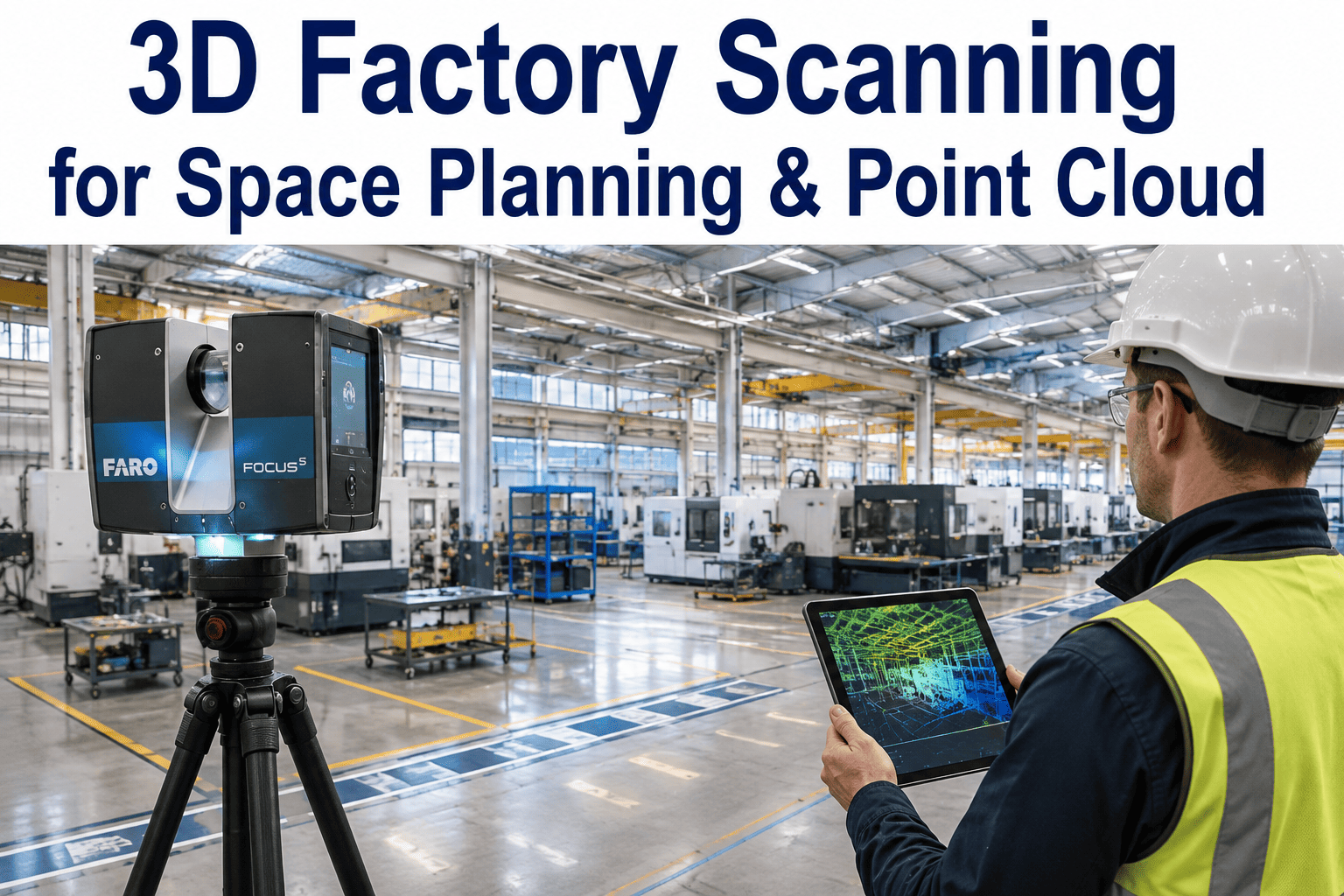
Every plant has a set of floor plan drawings somewhere in a shared drive, and almost none of them match what's actually on the floor today. A column got relocated during a 2019 expansion, a conveyor was rerouted around a new press, a mezzanine was added for storage — and none of it made it back into the CAD file. When an engineering team plans a new equipment installation off that outdated drawing, the mismatch doesn't surface until installation day, when a crane, a conduit run, or a support beam turns out to be exactly where the new equipment was supposed to go. A 3D laser scan replaces assumption with a millimeter-accurate record of what is actually there. Plants planning a layout change, expansion, or equipment installation can Book a Demo to see point cloud data turned into an actionable space planning model.
Why Outdated Floor Plans Are More Expensive Than They Look
Most facilities are running on as-built drawings that were accurate the day they were filed and have drifted further from reality with every uncoordinated change since. The gap between drawing and floor doesn't cause a problem until someone plans against it — and by then, the cost has already shifted from a scanning fee to a change order.
The most expensive version of this problem shows up during equipment installation, when a rigging crew discovers a support column, an overhead conduit run, or a neighboring machine's true footprint doesn't match the drawing they planned around. At that point the fix isn't a drawing revision — it's a delayed install, an idle crew, and in many cases a redesigned mounting plan on the spot.
This kind of drift accumulates gradually and almost never gets corrected on its own. A drawing gets updated for a major renovation, and then every small change afterward — a relocated junction box, a rerouted air line, a temporary support that became permanent — gets fixed in the field without ever making its way back to the CAD file. Multiply that pattern across a facility that's been operating for a decade or more, and the drawing on file becomes less a record of the plant and more a rough historical sketch that happens to share the same building outline, useful for orientation but not for the level of precision an installation plan actually needs.
How 3D Factory Scanning Actually Works
The process behind a laser-scanned facility model is more straightforward than most teams expect, and understanding the sequence makes it easier to see where the accuracy and value actually come from at each stage.
Laser Scanning Captures the Space
A LiDAR scanner emits laser pulses across every surface in range and measures the return time of each pulse to calculate distance — the Time of Flight principle — building millions of precise coordinate points per scan position.
Multiple Scans Are Registered Together
A facility requires scanning from several positions to capture every angle without shadow gaps. Registration software stitches these individual scans into one continuous, georeferenced point cloud of the full space.
The Point Cloud Becomes a 3D Model
Modeling software traces structural columns, walls, ductwork, piping, and equipment footprints from the raw point data into an intelligent, dimensioned 3D model ready for planning and design work.
New Designs Are Overlaid and Tested
Proposed equipment, conveyors, or structural changes are placed directly into the accurate model, where clash detection software flags any conflict with existing conditions before a single bolt is ordered.
None of these steps require specialized skills from the plant side beyond granting site access and, where relevant, scheduling around production. The scanning crew handles capture and registration, and most providers deliver the finished model in a standard CAD or BIM format that a plant's own engineering team can open directly, without needing to license or learn the scanning software itself. This matters most for smaller plants without a dedicated facilities engineering group, since the barrier to using a scanned model well is far lower than the barrier to producing one.
Choosing a Capture Method: Accuracy vs. Speed
Not every space planning task needs the same level of precision, and matching the capture method to the decision being made keeps both cost and turnaround time reasonable.
| Method | Typical Accuracy | Best Fit |
|---|---|---|
| Terrestrial Laser Scanning (LiDAR) | ±1 to 3 mm | Clash detection, prefabrication, precision equipment installation |
| Photogrammetry (Drone or Handheld) | ±20 to 50 mm | Interior layouts, floor plans, rapid coverage of large areas |
| Manual Tape and Laser Measure | Highly variable, error-prone | Small, simple spaces with low planning stakes only |
| Existing CAD Drawings | Unknown, frequently outdated | Not recommended as the sole source for any installation planning |
For most factory space planning work, the decision comes down to LiDAR versus photogrammetry. Photogrammetry is faster and less expensive, and its accuracy is more than sufficient for general layout and floor plan work. Terrestrial laser scanning costs more but is the only method precise enough to trust for clash detection, prefabrication, and any installation where a few centimeters of error could mean a misaligned mounting plate or a pipe run that doesn't clear a beam.
It's also worth noting these methods aren't mutually exclusive across a facility. Many plants use photogrammetry or drone capture to quickly document large, lower-stakes areas like warehouse aisles or general circulation space, then bring in terrestrial laser scanning specifically for the production cells, mechanical rooms, and installation zones where precision actually changes the outcome of a project. Blending methods this way keeps the overall cost of a facility-wide capture reasonable without sacrificing accuracy where it matters most, and it gives planning teams a sensible default when budget doesn't stretch to full-precision coverage of an entire site in one pass.
What a Single Scan Actually Captures
A common misconception is that a facility scan only produces a floor plan. In practice, a properly executed scan captures every physical layer of a space simultaneously, which is exactly what makes it valuable for space planning rather than just documentation.
Because all four layers are captured at once and in the same coordinate system, planners can test a proposed layout change against structure, utilities, equipment, and safety clearance simultaneously — something that's nearly impossible to do reliably with separate drawings that were each created at different times by different teams, using different scales, and often by different contractors who never coordinated with one another.
This simultaneity is easy to undervalue until you've tried to plan without it. A structural drawing from the original building permit, an electrical as-built from a 2015 retrofit, and a hand-sketched equipment layout from last quarter rarely share a common reference point, let alone a common level of accuracy. Reconciling them by hand is exactly the kind of manual cross-checking that a single, unified point cloud model eliminates in one step — every layer already shares the same coordinate system because it was captured in the same pass.
Catching Clashes Before They Reach the Install Crew
Clash detection is where a point cloud model earns back its cost fastest. Overlaying a proposed design onto the accurate as-built model lets software flag every spatial conflict automatically, long before equipment arrives on site.
Without a Scanned Model
Conflicts surface on install day — a beam blocks the planned crane path, a conduit run sits exactly where a new machine's footprint needs to go, and the crew improvises a fix under time pressure.
With a Scanned Model
Clash detection software highlights every conflict during the design phase, giving engineers weeks to redesign a mounting plan or reroute a utility instead of hours on an active install day.
This shift also changes who bears the risk of a planning error. Without a scanned model, the cost of an undiscovered clash lands on the install crew and the production schedule. With one, that same cost is absorbed quietly during design review — a far cheaper place for a mistake to surface, and one that never touches a live production line.
The financial case for clash detection is straightforward once a plant has been through one bad install. A change order triggered by an on-site clash typically costs several times what the original scan would have cost, once idle crew time, expedited redesign, and schedule slippage are added up. Plants that have absorbed that cost once tend not to skip the scanning step on the next project, regardless of how confident anyone feels about the existing drawings, and the lesson tends to stick with the engineering team for years afterward.
Where Point Cloud Data Drives Real Space Planning Decisions
Beyond clash detection, an accurate 3D facility model becomes the foundation for several ongoing planning decisions that most plants otherwise make with rough measurements and guesswork.
New Equipment Placement
Test whether a new machine's true footprint, service clearance, and utility connection points actually fit the intended location before it's ordered, not after it arrives on a truck.
Line Reconfiguration
Simulate moving a production line or workcell within the accurate model, checking material flow distances and aisle clearance against real dimensions instead of an approximate sketch, and testing several layout options before committing floor time to a physical move.
Expansion and Renovation Planning
Hand architects and engineers a verified as-built model instead of assumptions, reducing the field changes and change orders that come from designing against outdated drawings and giving external design partners confidence in the starting conditions from day one.
Digital Twin Foundation
Use the scanned model as the geometric base layer for a broader digital twin initiative, since accurate physical geometry is the starting point every subsequent data layer builds on.
These use cases share a common thread worth calling out directly: none of them treat the scan as a one-time deliverable. A model built for an initial equipment placement decision doesn't stop being useful once that project closes — it becomes the reference the next planner reaches for, the baseline a maintenance team checks clearance against, and the starting geometry a digital twin project builds sensor data onto. The upfront capture cost is fixed, but the number of decisions it eventually supports keeps growing for as long as the model stays current.
Rolling Out a Facility Scanning Program
Plants new to 3D scanning don't need to capture the entire footprint on day one. A phased approach delivers value fast on the highest-stakes areas while the broader model builds out over time.
Scan the Highest-Change Areas First
Prioritize zones with upcoming installations, frequent layout changes, or the oldest, least trustworthy drawings, where the payoff from an accurate model is most immediate.
Build the Model and Validate
Convert the point cloud to a dimensioned model and spot-check it against a handful of field measurements to confirm accuracy before relying on it for planning decisions.
Run Clash Detection on Active Projects
Overlay any in-progress equipment or layout project onto the model immediately, catching conflicts on projects already underway rather than waiting for a future scan cycle.
Expand Coverage and Keep It Current
Extend scanning to the rest of the facility over subsequent phases, and re-scan any area after a significant physical change so the model doesn't drift back into the same outdated state.
Treating the model as a living reference rather than a one-time snapshot is what separates plants that get lasting value from scanning and those that let a perfectly accurate model quietly go stale within a year or two. Building a simple rule — any project that physically alters structure, utilities, or major equipment placement triggers a partial re-scan of that zone — keeps the model honest without requiring a full facility re-capture on any regular schedule.
What Plants Gain From an Accurate 3D Facility Model
The return on a scanning program compounds with every project that uses the model instead of a stale drawing. Plants that build out even a partial scanned footprint consistently report the following shifts.
The scan itself is a one-time capture, but the value doesn't expire the moment the model is delivered. Every equipment purchase, line move, or renovation project that follows draws on the same accurate geometry, which is why plants that scan proactively tend to describe the cost less as a project expense and more as infrastructure the whole engineering team leans on for years afterward.
There's also a less obvious benefit that shows up in how planning conversations happen once a model exists. Disagreements about whether something will fit, whether an aisle is wide enough, or whether a proposed layout leaves adequate service clearance stop being debates settled by memory or a quick tape measurement and start being questions the model can answer directly, on screen, in the same meeting where the decision needs to get made. That shift alone tends to compress planning timelines even before accounting for the rework it prevents.
Frequently Asked Questions: 3D Factory Scanning and Space Planning
How accurate is a 3D laser scan compared to traditional measurements?
Terrestrial laser scanning in industrial environments typically achieves accuracy in the range of one to three millimeters, far tighter than manual tape measurements and consistent enough to trust for clash detection and prefabrication work. Photogrammetry, which uses overlapping photographs instead of laser pulses, is less precise at roughly twenty to fifty millimeters but is faster and less expensive, making it a reasonable choice for general floor plans and layout work where that level of precision isn't required. The right method depends entirely on what decision the model needs to support, and it's worth discussing the intended use case with a scanning provider before committing to one method over the other, since switching methods partway through a project rarely saves money compared to choosing correctly up front.
How long does it take to scan a full production facility?
A high-speed scanner can capture a single room or production cell in a matter of minutes, though a full facility requires scanning from multiple positions to eliminate shadow gaps behind equipment and columns, which extends total capture time depending on facility size and layout complexity. Most plants find that scanning happens far faster than the manual measurement process it replaces, and unlike a manual survey, a scan rarely requires a return trip to capture something that was missed the first time.
Can a facility scan happen without stopping production?
Yes, in most cases scanning can be scheduled around active production with minimal disruption, particularly when planned during a shift change, a scheduled downtime window, or off-peak hours for the specific area being captured. Some congested or safety-sensitive zones may require brief access windows, but a scanning provider experienced in industrial environments will typically plan the capture sequence to minimize interference with ongoing operations rather than requiring a full production stoppage. Coordinating the scan schedule with area supervisors ahead of time also helps, since moving a piece of mobile equipment out of a scanner's path for a few minutes is far easier to arrange in advance than to improvise on the day of capture.
What happens to the point cloud data after the scan is complete?
The raw point cloud is typically processed into a dimensioned 3D model, 2D CAD drawings, or both, depending on what the planning team needs. From there, the model can be used directly for clash detection, shared with engineering and architecture teams for expansion planning, or layered into a broader digital twin initiative as the geometric foundation. Delivered file formats generally follow standard CAD or BIM conventions so an existing engineering team can open and work with the model without adopting new software just to view it. Teams looking to connect scan data into an ongoing space planning workflow can contact iFactory Support for guidance on integration.
Is scanning worth it for a facility that isn't planning a major expansion?
Yes — the value isn't limited to large capital projects. An accurate scanned model pays for itself through smaller, more frequent decisions: placing a single new machine correctly the first time, planning a line move without a surprise clash, or simply having a reliable reference the next time someone asks how much clear floor space actually exists in a given area. Plants that scan proactively, rather than only before a major project, tend to get the most cumulative value from the investment over time, largely because the cost of capture is fixed while the number of small planning decisions the model quietly improves keeps accumulating for as long as the facility stays in operation.