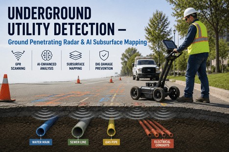
Somewhere in the United States, an underground utility line is struck every 30 seconds. Not every hour. Not every shift. Every 30 seconds — 365 days a year. The Common Ground Alliance's 2024 DIRT Report analysed nearly 200,000 confirmed damage cases and found that the industry is moving in the wrong direction: the CGA Index rose from 94.0 in 2023 to 96.7 in 2024, signalling that efforts to reduce damages are plateauing while construction activity continues to climb. The total societal cost of excavation-related utility damage in the US exceeds $30 billion annually, a figure that accounts for direct repair costs, service disruption losses, business interruption claims, medical expenses from injuries, and legal liability. Beneath every construction site, road rehabilitation project, and utility upgrade lies a dense, undocumented web of buried infrastructure — water mains installed 50 to 80 years ago, gas lines mapped on paper records from the 1960s, telecom conduits added without any central registry, and electrical ducts that have been repaired so many times that the as-built drawings no longer match reality. Ground penetrating radar enhanced by artificial intelligence is changing how asset owners and contractors see what is underground — and how they prevent the strikes that cost lives, delay projects, and erode margins.
$30 Billion in Annual Damage. Zero Excuses. iFactory Connects What You Find Underground to What You Do About It.
iFactory's asset management platform ingests GPR and subsurface mapping data, links every detected utility to its asset record, and ensures that excavation teams, reliability engineers, and maintenance planners share one source of truth about what lies beneath every site.
Annual societal cost of excavation-related utility damage in the US — including direct repairs, service disruption, business interruption, injuries, and legal liability
700K+
Underground utility lines struck annually across the US — one line damaged approximately every 45 seconds during construction and excavation activity
29:1
Ratio of indirect and social costs to direct repair costs per utility strike — a $2,000 repair can cascade into $60,000 or more in total losses
421
Fatalities caused by utility strikes since 2000 — with over 2,000 additional injuries — making subsurface detection a safety imperative, not just a cost-control measure
The $30 Billion Problem — Why Utility Damages Keep Rising Despite Better Technology
The Common Ground Alliance's 2024 DIRT Report analysed 196,977 confirmed damage cases and found that the top 10 root causes accounted for 85% of all reported incidents. The patterns have remained stubbornly consistent year over year — suggesting that the problem is not the absence of detection technology, but the gap between the data that technology produces and the decisions that excavators, locators, and asset owners make with it.
Failure to Notify 811
24.5%
Nearly one in four utility strikes occurs because the excavator did not contact the one-call centre before breaking ground. This is the single largest preventable cause — and it is entirely a process failure, not a technology gap. Mandatory 811 notification before any excavation remains the most effective single intervention, yet compliance remains inconsistent across jurisdictions.
Excavator Not Maintaining Clearance
16.1%
Even when utilities are located and marked, excavators dig outside the tolerance zone or fail to maintain the required clearance. This root cause points to a gap between the locate data provided and the excavation plan executed — a gap that closes when locate data is integrated directly into the dig plan rather than communicated on a paper sketch or PDF that stays in the truck cab.
Locator Errors — Unmarked or Inaccurately Marked
20.5%
Combined, facilities that were either never marked (11.9%) or marked inaccurately (8.6%) account for over a fifth of all damages. Inaccurate marking often results from outdated utility records, congested subsurface environments where multiple utilities occupy the same trench, or the inherent limitations of electromagnetic locating — which cannot detect non-metallic pipes or conduits. This is where ground penetrating radar and AI-enhanced subsurface mapping provide their greatest value.
Improper Excavation + Digging Before Verification
11.7%
Together, improper excavation practices (6.8%) and digging before verifying marks (4.9%) account for the fourth cluster of preventable damages. These failures often occur under schedule pressure — when project timelines compress and the pre-dig verification step is skipped. A subsurface map that lives in a maintenance management system rather than on a paper sheet is far harder to ignore or skip.
How AI-Enhanced Ground Penetrating Radar Works — From Radar Pulse to Subsurface Map
Ground penetrating radar has been used for utility detection for decades, but the addition of artificial intelligence has transformed it from an expert-dependent interpretation tool into a repeatable, scalable subsurface mapping capability. The global GPR market is projected to grow from $457 million in 2025 to $882 million by 2034, driven largely by AI integration and the demand for non-destructive utility detection before excavation. The process follows four distinct stages, each enhanced by machine learning models that improve accuracy with every survey.
01
Transmit
A GPR antenna emits high-frequency electromagnetic pulses (typically 200–900 MHz for utility detection) into the ground. The frequency determines depth penetration versus resolution — lower frequencies reach deeper but resolve fewer details, higher frequencies capture finer features at shallower depths.
02
Reflect
When the radar pulse encounters a buried object or a boundary between materials with different dielectric properties — a PVC water main, a ductile iron gas pipe, a concrete-encased electrical duct bank, or a void — part of the signal is reflected back to the antenna. The time delay between transmission and reception encodes the depth of each reflector.
03
Process
AI models process raw radargram data to distinguish utility signatures from geological clutter, root systems, and other buried anomalies. Machine learning classifiers trained on thousands of labelled GPR surveys identify pipe types, conduit materials, and depth with 30% higher interpretation accuracy than manual analysis alone — and they improve with every additional survey fed into the training dataset.
04
Map
Processed detections are georeferenced and exported as a subsurface utility map — showing pipe alignments, depths, material types, and confidence levels for each detection. The map integrates with iFactory's asset hierarchy so every buried utility is a trackable asset with a location, condition baseline, and inspection history accessible to anyone planning excavation work.
Four Buried Asset Types — What GPR with AI Detects and Why It Matters for Each
Different buried utilities present different detection challenges. Metallic pipes are detectable with electromagnetic methods alone, but non-metallic utilities — PVC water mains, HDPE gas lines, concrete sewer pipes, and fibre optic conduits — are invisible to conventional locators. GPR detects all materials, and AI classification identifies the utility type from the radar signature, enabling a comprehensive subsurface map regardless of pipe material.
Water Mains
452K miles beyond life
20% of North America's 2.3 million miles of water mains are beyond their useful lives. The US and Canada experience 260,000 water main breaks annually at $2.6 billion in repair costs. PVC, ductile iron, and asbestos cement pipes — many non-metallic — make electromagnetic locating unreliable. AI-enhanced GPR detects water mains of any material, measures depth of cover, and identifies surrounding soil voids that signal imminent collapse risk.
Sewer & Storm Lines
Concrete & vitrified clay
Sewer and stormwater lines are typically concrete, vitrified clay, or HDPE — none detectable by electromagnetic locators. GPR identifies their alignment, depth, and condition, including sags, cracks, and joint displacements that precede collapse. AI models trained on sewer radar signatures distinguish pipe walls from surrounding soil and flag anomalous reflections that indicate structural deterioration before a sanitary sewer overflow occurs.
Gas Pipes
Steel, PE, cast iron
Gas distribution networks include steel, polyethylene, and cast iron pipes — with polyethylene being entirely invisible to electromagnetic locators. A gas line strike can cause explosions, evacuations, and fatalities. The 2014 Asheville gas line explosion, triggered by an excavation error 11 years prior, cost over $800,000 with zero injuries. GPR detects PE gas lines by the dielectric contrast between the pipe wall and the surrounding soil, and AI classification identifies the pipe material from the radar waveform signature.
Electrical Conduits
PVC, concrete-encased
Electrical duct banks are often PVC conduits encased in concrete — detectable by GPR but invisible to electromagnetic methods unless a tracer wire was installed and remains intact. The cables inside may carry medium-voltage power, and a strike can cause arc flash, electrocution, and prolonged outages. GPR locates the duct bank envelope, and AI analysis differentiates between multiple conduit layers within the same trench, providing excavators with the precise horizontal and vertical position of each duct before any digging begins.
Subsurface Data · GPR Integration · Utility Asset Records · Excavation Safety
If It Is Not in Your Asset Management System, It Does Not Exist. iFactory Puts Every Buried Utility on the Map.
iFactory ingests GPR survey data, georeferenced utility maps, and AI detection outputs — turning every subsurface scan into a permanent, accessible asset record that excavation teams consult before breaking ground.
Traditional Utility Locating vs. AI-Enhanced GPR Subsurface Mapping — The Five Critical Differences
Electromagnetic locating — the conventional method for finding buried utilities — works well on metallic pipes and tracer wire-equipped lines but fails on the growing share of non-metallic infrastructure being installed today. AI-enhanced GPR bridges this gap, and the differences between the two approaches define how reliably an organisation can prevent utility strikes across a diverse buried asset portfolio.
Traditional Electromagnetic Locating vs. AI-Enhanced GPR Subsurface Mapping
Dimension
Traditional Electromagnetic Locating
AI-Enhanced GPR Subsurface Mapping
Material detection
Detects only metallic pipes and conduits with tracer wires. PVC, HDPE, concrete, vitrified clay, and fibre optic are invisible — creating dangerous blind spots in the locate.
Detects any material with dielectric contrast against the surrounding soil — including all plastics, concrete, clay, and composites. No tracer wire required. AI classifies material type from the radar signature.
Depth accuracy
Depth estimation is based on signal strength fall-off, which varies with soil conductivity, moisture content, and pipe material. Accuracy degrades significantly in heterogeneous soils.
Depth is calculated from precise two-way radar travel time, corrected for soil dielectric properties. Typical accuracy within 5–10% of true depth across a 0.3 m to 6 m range, depending on antenna frequency.
Congested environments
When multiple metallic utilities share a trench, electromagnetic signals couple and produce inaccurate readings. Operators must disconnect or isolate lines — often impractical in active networks.
GPR resolves multiple utilities in the same trench by spatial separation in the radar cross-section. AI models trained on congested urban surveys differentiate overlapping signatures with high classification accuracy.
Data permanence
Locate marks are paint on the ground and flags — temporary, weather-dependent, and gone once construction begins. No permanent record of what was found or where it was marked.
Every survey produces a georeferenced subsurface map that lives in iFactory as a permanent asset record. The data is accessible for future excavation planning, condition trending, and regulatory compliance — not erased by rain or construction traffic.
Skill dependency
Results depend heavily on operator experience. Novice locators miss lines, misinterpret signals, and produce inconsistent coverage. Industry-wide locator shortage is worsening the problem.
AI interpretation reduces operator dependency. The system flags detections with confidence scores, highlights ambiguous areas for operator review, and improves its accuracy with every survey — making consistent results achievable with less experienced field personnel.
Why Subsurface Data Must Live in Your Asset Management System — Not on a Paper Map or a Hard Drive
The organisations that consistently prevent utility strikes share a common characteristic: they treat subsurface utility data as a managed asset rather than a project deliverable. When a GPR survey is completed and the data is filed in a drawer or saved on a local computer, its value is limited to the single excavation event for which it was commissioned. When that same data is ingested into iFactory as a permanent asset record linked to every buried utility on the site, its value compounds with every subsequent dig, every condition assessment, and every capital planning cycle.
Every excavation begins with accurate data, not a phone call
When subsurface utility maps live in iFactory, a project manager planning an excavation opens the asset record for the site and sees every known buried utility — its material, depth, alignment, and the date of the most recent GPR survey. No waiting for paper records, no relying on paint marks that may have faded, no guessing whether a utility was ever mapped.
Condition data accumulates across survey cycles
GPR surveys conducted over successive years create a condition history for each buried asset. A water main that showed minor wall thinning in the 2023 survey may show accelerated deterioration in 2025 — the system flags the trend and alerts the reliability engineer before a break occurs. This is the difference between reactive repair and predictive condition management.
Compliance documentation is generated automatically
Regulatory requirements for subsurface utility engineering, damage prevention programmes, and excavation safety protocols require documented proof that utilities were located before work began. iFactory maintains a complete audit trail: when each survey was conducted, what it found, who reviewed the results, and how the data was communicated to the excavation team. This record is available for inspection, audit, or legal defence at any time.
Capital planning is informed by actual buried asset condition
The $452 billion funding gap for water infrastructure replacement in the US and Canada exists partly because utilities lack accurate condition data on their buried assets. GPR surveys ingested into iFactory provide the condition baseline that transforms reactive replacement budgeting into data-driven capital planning — directing有限 dollars to the pipes most likely to fail next, rather than replacing based on age alone.
"
We were managing 1,200 miles of water and sewer mains with paper maps and institutional knowledge. When a contractor would call to locate utilities for a road project, someone who had been with the utility for 20 years would walk the site and point to where they remembered the pipes being. We had a preventable main break during excavation in the first year I was there — the as-built drawing showed the main four metres from where it actually was. That was the moment I started putting every GPR survey result into our asset management system. Two years later, we had a complete subsurface map of our entire distribution network, every pipe with a condition score, and the excavation contractor pulled up the map on a tablet before breaking ground. The strike rate dropped to zero in the third year. Zero. That is what happens when subsurface data is treated as a managed asset rather than a project file.
— Director of Utility Asset Management, Regional Municipal Water Authority — 28 Years in Water and Wastewater Infrastructure
Conclusion
The $30 billion annual cost of excavation-related utility damage in the United States is not a technology problem. The technology to detect buried utilities exists — ground penetrating radar has been commercially available for decades, and AI-enhanced subsurface mapping now delivers detection accuracy and classification capability that exceeds anything the industry has had before. The gap is an information management problem: subsurface data collected during one project is not accessible for the next; locate marks vanish with the first rain; utility records are scattered across paper files, PDFs, and institutional memory; and there is no single system that connects what is underground to the people who need to know about it before they dig.
iFactory closes that gap. The platform ingests GPR subsurface mapping data, georeferences every detected utility against your asset hierarchy, maintains a permanent condition history across survey cycles, and makes the complete subsurface picture available to excavation teams, reliability engineers, and capital planners through a single interface. Talk to an expert to discuss how iFactory can integrate your subsurface data into a managed asset programme, or book a demo to see the platform in action with your utility network data.
Frequently Asked Questions
iFactory accepts structured subsurface data from GPR survey providers, AI processing platforms, and GIS utility mapping tools through API integration or structured file import (including shapefiles, GeoJSON, CSV with coordinate data, and DXF utility maps). Each detected utility feature — a pipe segment, a conduit run, a manhole, a valve — is mapped to an asset record in iFactory's asset hierarchy, with attributes including material type, depth, diameter, installation date (if known), survey confidence score, and a link to the source radargram or survey report. Once ingested, each buried utility becomes a tracked asset with a unique identifier, location data, condition history, and maintenance records — just like any above-ground asset in the system. Talk to an expert to discuss how your existing GPR survey data formats can integrate with iFactory's asset hierarchy and subsurface mapping modules.
Yes. iFactory supports multiple data layers within the same asset hierarchy — public utility records from one-call centres, private subsurface survey data from GPR providers, as-built drawings from construction projects, and condition assessment data from inspection programmes. Each data layer is tagged with its source, date, and confidence level, so excavation teams can see not just where utilities are supposed to be according to public records, but where they were actually detected by the most recent GPR survey. Discrepancies between layers are highlighted automatically — a pipe that appears on the as-built drawing but was not detected by GPR, or a utility that was found by GPR but does not appear in any public record — flagging areas that require additional investigation before excavation. Book a demo to see how iFactory's multi-layer subsurface mapping interface consolidates data from public and private sources into a single excavation-ready view.
iFactory's workflow engine can enforce pre-excavation verification as a gate step in any work order that involves digging. Before a work order status can be advanced to "in progress" for any excavation task, the system can require confirmation that 811 has been notified, that GPR survey data has been reviewed, and that the subsurface utility map has been acknowledged by the person responsible for the dig. This turns the 811 notification requirement from a process that happens separately from the maintenance workflow — and is often forgotten under schedule pressure — into a mandatory, tracked step within the same system that manages the work. Organisations using iFactory's pre-dig verification workflows report that the 811 notification compliance rate moves from an estimated 60–70% industry average to over 95% within the first two quarters of deployment. Talk to an expert to set up pre-excavation verification workflows for your maintenance and construction teams.
The return on investment from integrating subsurface data into a managed asset platform typically materialises in three areas. First, strike prevention: organisations that move from paper-based locate records to digital subsurface maps in an asset management system report a 60–80% reduction in excavation-related utility strikes within 12 to 18 months — with each prevented strike saving an average of $4,000 in direct costs and up to $60,000 in total societal costs. Second, survey data reuse: a single GPR survey that costs $5,000–$15,000 for a typical urban site is currently used for one excavation project and then archived or discarded. When ingested into iFactory, that same survey is accessed for every subsequent dig on the same site — eliminating the cost of re-surveying and compressing project timelines. Third, capital planning: utilities using condition data from successive GPR surveys to prioritise pipe replacement report 20–30% reductions in emergency repair spending, as proactive replacements cost significantly less than reactive emergency repairs. Book a demo to discuss a cost-benefit analysis tailored to your utility network or infrastructure portfolio.
One Utility Strike Every 30 Seconds. iFactory Helps Make Every One Preventable.
From GPR survey ingestion to pre-dig verification workflows to condition-based capital planning — iFactory turns subsurface data into a managed asset that protects your buried infrastructure, your project budgets, and your people.